The Amazon River Map is the second-longest river in the world and the largest river in South America. Covering a distance of 6400 km from the headwaters of the Apurimac River system, it is the mightiest river in the world in terms of its volume and largest drainage into the Atlantic Ocean.
Here, we are providing our users with a map of the Amazon River with detailed labeling to help them in studies and research-related purposes. The maps are downloadable and printable.
Quick Facts –
Ek attractive table add karein.
| Feature | Details |
|---|---|
| River Length | Approx. 6,400 km |
| Source | Andes Mountains, Peru |
| Mouth | Atlantic Ocean |
| Countries | Peru, Colombia, Brazil |
| Basin Area | Around 7 million sq km |
| Major Tributaries | Rio Negro, Madeira, Tapajós, Xingu |
| Known For | Largest river by discharge |
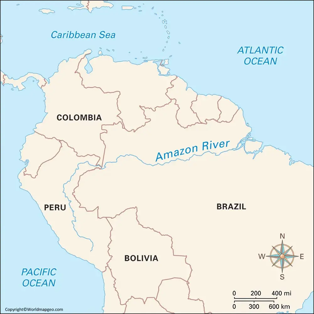
Amazon River Map
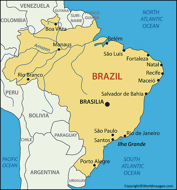
The Amazon River is a colossal waterway winding its way through the heart of South America. As the world’s largest river by discharge volume, it plays a vital role in the region’s ecosystem and serves as a lifeline for countless communities. When exploring an Amazon River map, you’ll witness the awe-inspiring expanse of this natural wonder. The river originates in the Peruvian Andes and flows eastward across the continent, meandering through Peru, Colombia, and Brazil before finally emptying into the Atlantic Ocean.
The Amazon River map showcases the extensive network of tributaries that contribute to its immense flow, with major ones like the Rio Negro and the Madeira River joining forces to create this mighty watercourse. The river’s basin is a lush expanse of tropical rainforest, teeming with unparalleled biodiversity and hosting countless plant and animal species found nowhere else on Earth.
Navigating an Amazon River map allows travelers and researchers to understand the geography of the region and the significant role this waterway plays in the lives of millions of people. Whether you’re planning a journey through the Amazon rainforest or simply seeking to appreciate the marvel of this natural phenomenon, exploring an Amazon River map is sure to leave you captivated by the scale and beauty of this extraordinary river. You might also want to check out Labeled Lake map:- Lakes of The World Map Labeled.
Amazon River on Map
Locating the Amazon River on a map is a fascinating way to grasp the vastness and importance of this iconic river system. The Amazon River courses through several South American countries, and finding it on a map requires identifying key geographical features. The river’s source lies high in the Andes Mountains of Peru, and from there, it traverses eastward, flowing through dense tropical rainforests and sprawling lowlands.
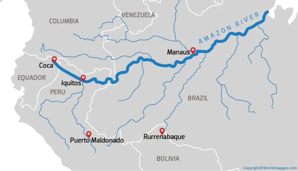
You can spot the Amazon River on a map as it winds its way through countries such as Peru, Colombia, and Brazil. The Amazon Basin, an enormous drainage basin covering approximately 7 million square kilometers, is also visible on the map, highlighting the vast area influenced by the river and its tributaries.
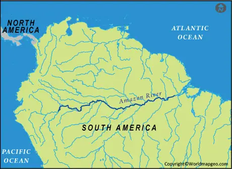
The Amazon River on a map showcases the extensive network of waterways, both major and minor, that make up this intricate system. With its numerous tributaries, the Amazon River plays a crucial role in regulating the region’s climate and supporting the incredible biodiversity found in the surrounding rainforest.
Where is the Amazon River Located on a Map
The Amazon River, one of the world’s most significant waterways, can be easily located on a map of South America. It primarily flows through the northern half of the continent, with its headwaters originating in the Peruvian Andes. As you examine a map, you’ll notice the Amazon River’s path as it snakes across the rainforests of Peru, Colombia, and Brazil.
To precisely identify where the Amazon River is located on a map, trace its course from its source in the Andes Mountains, through the dense jungles and lowlands of South America, and finally to its mouth at the Atlantic Ocean. The Amazon River and its extensive network of tributaries form an intricate network that provides a lifeline for countless communities and ecosystems in the region.
The river’s enormous basin encompasses multiple countries, covering approximately 40% of South America’s land area. Its water flow is so immense that it accounts for about one-fifth of the world’s total river discharge into the oceans. Discovering the location of the Amazon River on a map offers a glimpse into the sheer magnitude and ecological importance of this natural wonder.
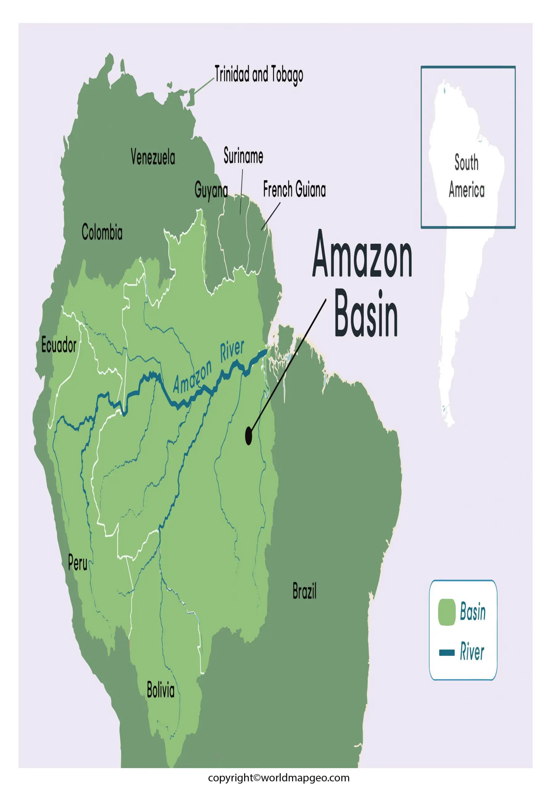
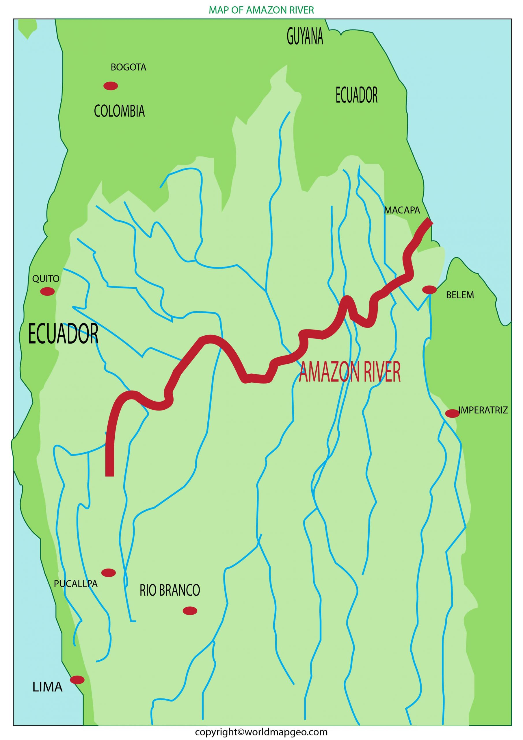
Amazon River Map Labeled
An Amazon River map labeled with key features is a valuable resource for gaining insights into the geography of this iconic waterway. As you explore the labeled map, you’ll find the river’s main course, starting from its source in the Andes Mountains and running through Peru, Colombia, and Brazil before reaching the Atlantic Ocean.

The Amazon River map includes labels for major tributaries, such as the Rio Negro, Madeira River, and the Purus River, which contribute significantly to the river’s voluminous flow. These tributaries, together with countless smaller ones, form an intricate network that sustains the remarkable biodiversity of the Amazon rainforest.
In addition to waterways, a labeled Amazon River map highlights key cities and towns along its course, underscoring the river’s importance as a vital transportation route and a source of livelihood for local communities. The map may also identify protected areas and national parks within the Amazon Basin, emphasizing the need for conservation efforts to preserve this ecological treasure.
A labeled Amazon River map is an educational tool that enables students, researchers, and travelers to deepen their understanding of the river’s geography, ecology, and cultural significance, making it an essential resource for anyone seeking to explore the wonders of the Amazon River region.
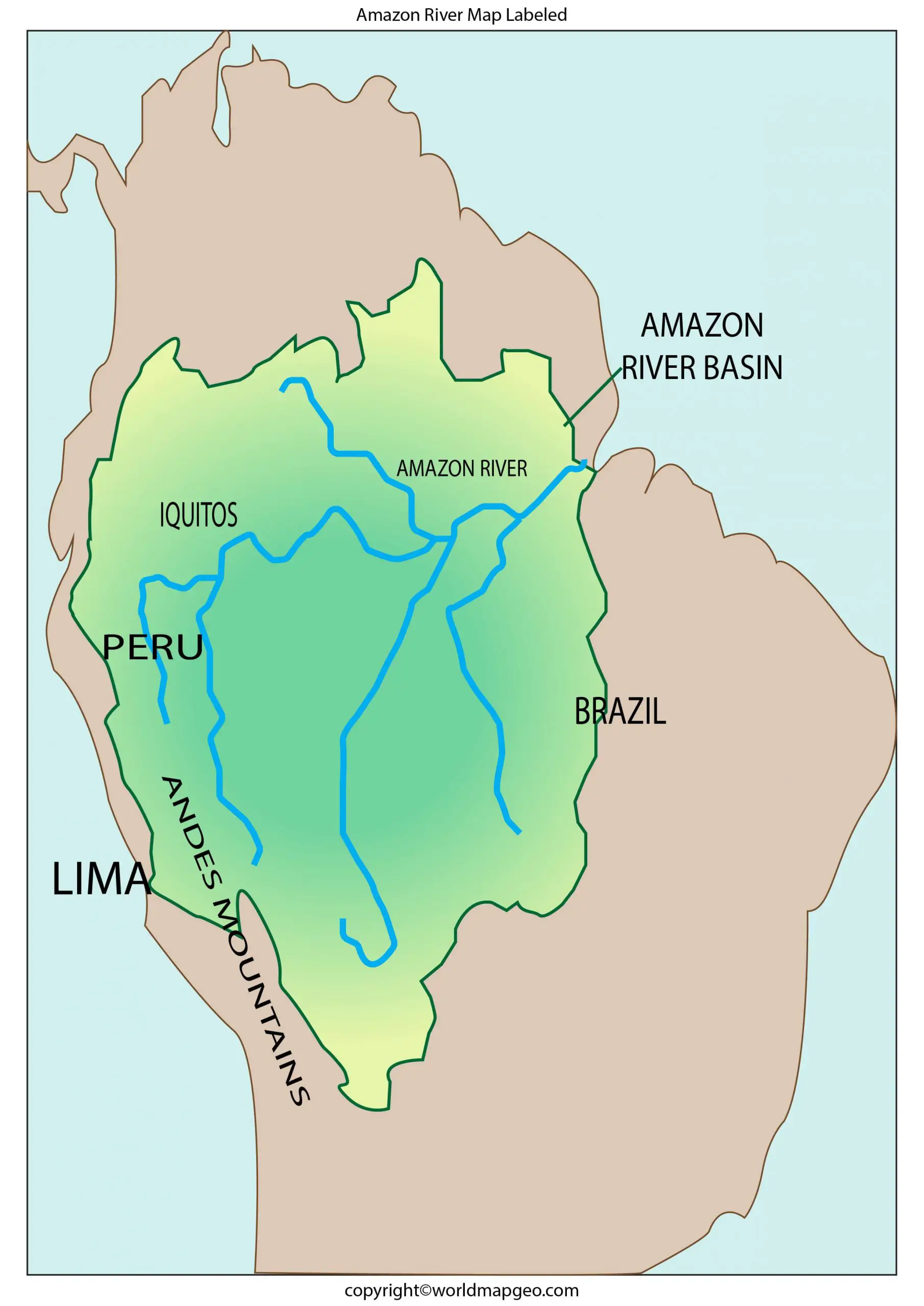
Map of Amazon River
A map of the Amazon River provides a comprehensive visual representation of this majestic watercourse and its vast drainage basin. This sprawling river system is located in South America, crossing through Peru, Colombia, and Brazil. Its headwaters are found high in the Andes Mountains, and from there, it flows eastward, eventually reaching the Atlantic Ocean.
A map of the Amazon River displays the main river channel as it meanders through dense rainforests and extensive floodplains. Alongside the river’s primary course, you’ll notice numerous tributaries that feed into its waters, sustaining the rich biodiversity of the surrounding Amazon Basin.
The Amazon River map also highlights the regions that depend on the river for transportation, agriculture, and sustenance. Many settlements and cities have developed along the riverbanks, utilizing its resources for various purposes. Understanding the map’s details allows us to appreciate the significance of the Amazon River in supporting both human communities and an incredible array of plant and animal species.
Whether you’re planning a trip to explore the wonders of the Amazon rainforest or simply fascinated by the natural beauty and ecological importance of this iconic river, a map of the Amazon River offers a captivating perspective on the world’s largest river system.
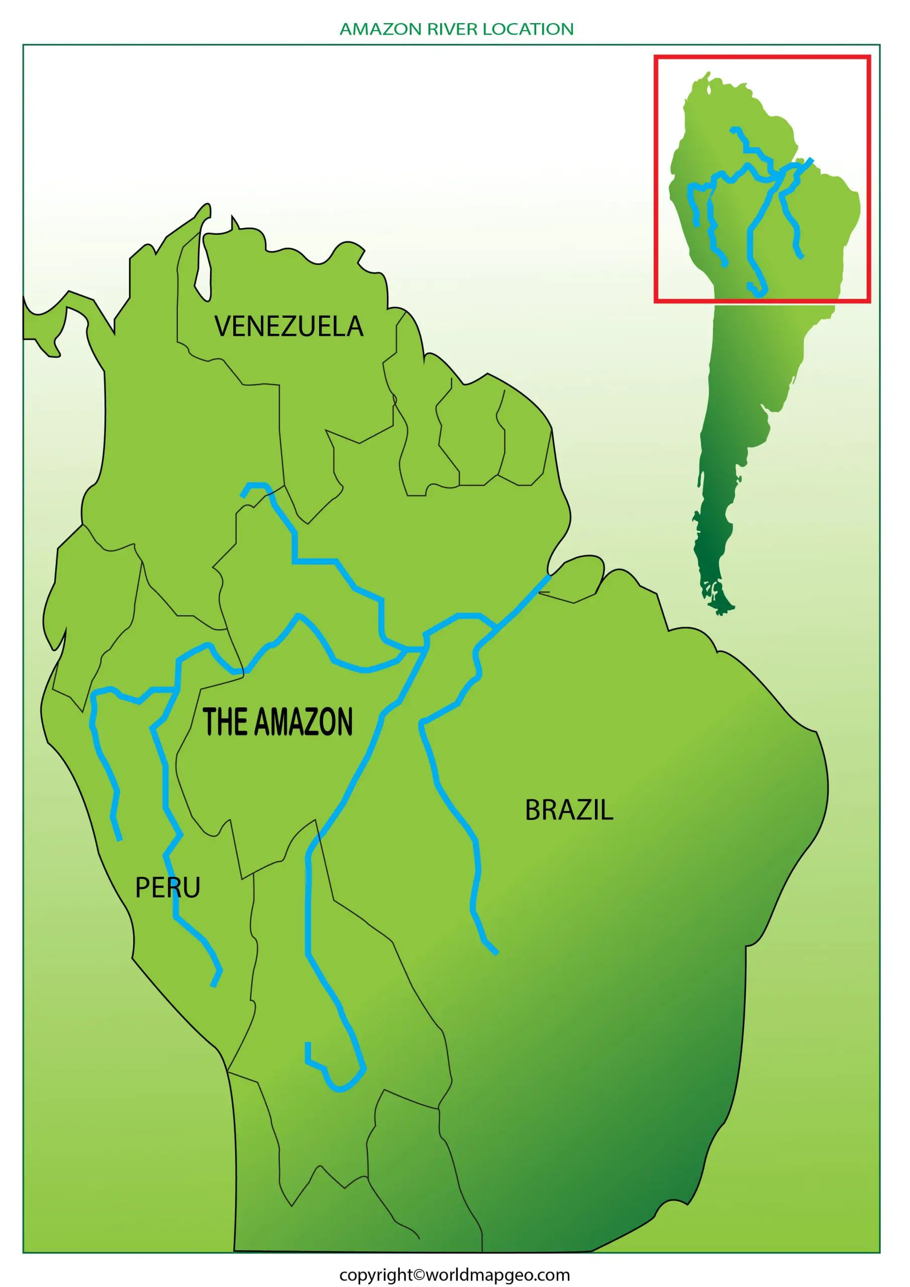
South America Amazon River Map
A South America Amazon River map showcases the extensive path of the Amazon River as it courses through a significant portion of the continent. Stretching across Peru, Colombia, and Brazil, the Amazon River and its basin cover a massive area that plays a pivotal role in the region’s ecological balance.
On this map, you can trace the Amazon River’s journey from its source in the Peruvian Andes, where it begins as a small stream, to its vast, meandering river form as it flows through the lush Amazon rainforest. The river’s intricate network of tributaries, labeled on the map, contributes to its prodigious water flow, making it the largest river in the world by discharge volume.
The South America Amazon River map not only illustrates the river’s natural wonders but also highlights the cultural and economic significance of the regions it traverses. Many cities and towns along its banks rely on the river for transportation, fishing, and agriculture, forging a deep connection between the river and the livelihood of local communities.
By exploring the South American Amazon River map, you’ll gain a deeper appreciation for the complexity and beauty of this vital waterway, as well as its indispensable role in shaping the ecosystems and societies of the Amazon Basin.
Related Post –
FAQs
1. Where does the Amazon River start and end?
The Amazon River starts in the Andes Mountains of Peru, near Nevado Mismi, and flows eastward through South America before emptying into the Atlantic Ocean in northern Brazil. An Amazon River map clearly shows its source, course, and mouth.
2. Which countries does the Amazon River flow through?
The main channel of the Amazon River flows through Peru, Colombia, and Brazil. However, the Amazon Basin extends into several other countries, including Bolivia, Ecuador, Venezuela, Guyana, Suriname, and French Guiana.
3. What can you see on a labeled Amazon River map?
A labeled Amazon River map typically shows the river’s source, mouth, major tributaries, surrounding countries, important cities, and the Amazon Basin. It is useful for students, teachers, and geography enthusiasts.
4. Can I download a printable Amazon River map?
Yes, many geography websites provide printable Amazon River maps in PDF or image format. These maps are ideal for classroom activities, school projects, quizzes, and educational reference.
5. Why is the Amazon River important?
The Amazon River is the largest in the world by water discharge and supports the Amazon Rainforest, one of Earth’s most biodiverse ecosystems. It provides freshwater, transportation, wildlife habitats, and plays a vital role in regulating the global climate.