Mountain Ranges Map: The majority of the world’s tallest peaks, including Mount Everest, are in Asia. At 8,848 meters (29,029 feet) above sea level at the Nepal-China border, Mount Everest is the tallest summit. Mount Goodwin-Austen, often known as K2, is a Himalayan peak that stands 8,611 meters (28,251 feet) tall in India (presently within the part of Kashmir occupied by Pakistan). Kanchenjunga, the world’s third-highest peak, is also found in the Himalayas, along the Nepal-China border (28,169 feet).
Related Post:
- World Time Zone Map
- Blank Map of Haiti
- Blank Map of Honduras
- World River Map
- South America Political Map
- World Map Physical
- Blank Map of Hungary
Mountain Ranges Map
A mountain ranges map is a topographic representation that highlights the various mountain systems across a specific region or the entire world. These maps provide crucial information about the distribution, elevation, and geographic features of mountain ranges. Typically, the map showcases different mountain peaks, passes, and valleys, allowing travelers, hikers, and geographers to gain a comprehensive understanding of the terrain.
Mountain ranges maps can vary in scale and detail, from local maps that focus on specific mountainous regions to broader maps that cover entire continents or the entire globe. Cartographers use contour lines to illustrate changes in elevation and create a three-dimensional view of the terrain. The spacing between these lines indicates the steepness of the slopes, helping adventurers gauge the difficulty of their journeys.
In addition to serving recreational and academic purposes, mountain ranges maps are invaluable tools for understanding the impact of these geological features on weather patterns, water drainage, and biodiversity. They also assist in identifying potential hazards such as landslides and avalanches, aiding in disaster management and land-use planning efforts. Check out other World Maps:- World Map HD, World Map Wallpaper.
What Is a Mountain Range?
A mountain range is a series of connected mountains that have formed through geological processes such as tectonic plate movement, volcanic activity, or erosion. Most mountain ranges stretch for hundreds or even thousands of kilometers and contain multiple peaks, valleys, glaciers, and rivers.
Mountain ranges are found on every continent and play an essential role in shaping regional climates, biodiversity, and human settlements.
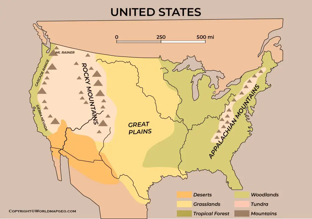
Major Mountain Ranges of the World
The world is home to many impressive mountain systems. Below are some of the most well-known mountain ranges and their locations.
| Mountain Range | Continent | Highest Peak | Countries |
|---|---|---|---|
| Himalayas | Asia | Mount Everest (8,849 m) | Nepal, China, India, Bhutan, Pakistan |
| Andes | South America | Aconcagua (6,961 m) | Argentina, Chile, Peru, Bolivia, Ecuador, Colombia, Venezuela |
| Rocky Mountains | North America | Mount Elbert (4,401 m) | United States, Canada |
| Alps | Europe | Mont Blanc (4,808 m) | France, Italy, Switzerland, Austria and nearby countries |
| Atlas Mountains | Africa | Jebel Toubkal (4,167 m) | Morocco, Algeria, Tunisia |
| Appalachian Mountains | North America | Mount Mitchell (2,037 m) | United States, Canada |
| Ural Mountains | Europe & Asia | Mount Narodnaya (1,895 m) | Russia, Kazakhstan |
| Great Dividing Range | Australia | Mount Kosciuszko (2,228 m) | Australia |
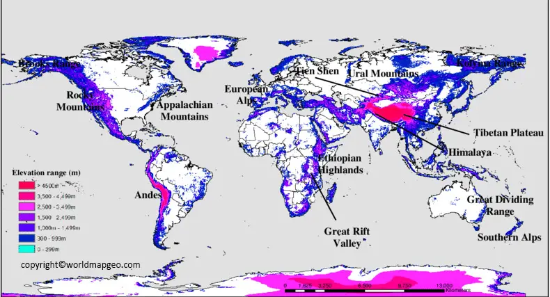
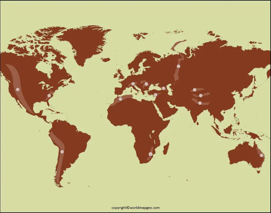
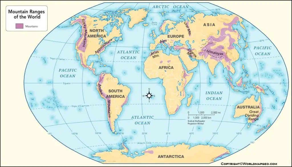
World Mountain Ranges Map
A world mountain ranges map is an expansive cartographic depiction of the major mountain systems that span across continents and countries worldwide. This map showcases the diversity and grandeur of Earth’s topography, providing viewers with a captivating visual of the planet’s tallest and most significant mountain ranges.
Among the prominent mountain ranges featured on this map are the Himalayas in Asia, the Andes in South America, the Rocky Mountains in North America, the Alps in Europe, and the African Rift Mountains. It also includes less well-known ranges in Oceania, Antarctica, and other remote regions.
The world mountain ranges map is an excellent educational resource, helping students and enthusiasts explore the geological processes that shaped these awe-inspiring features. Furthermore, it highlights the correlation between tectonic plate boundaries and the formation of mountain ranges, fostering a deeper appreciation for Earth’s dynamic geology.
For adventurers and mountaineers, this map serves as a source of inspiration, inviting them to embark on extraordinary journeys to conquer the highest peaks and experience diverse cultures and climates along the way. Moreover, the map serves as a reminder of the importance of preserving these natural wonders and the ecosystems they support.
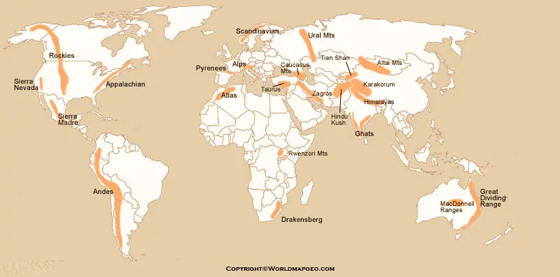
Labeled Mountain Ranges Map
A labeled mountain ranges map provides a comprehensive and informative view of various mountain systems across a specific region or the entire globe. This map is enhanced with detailed labels, identifying the names of individual mountain ranges, peaks, and geographical features. By incorporating labels, it becomes a valuable reference tool for travelers, researchers, and educators.
The labeled mountain ranges map is an excellent resource for educational purposes, helping students of all ages learn about different mountain ranges’ names, locations, and elevations. This visual aid aids in memorization and comprehension, making it easier to understand the geographic distribution of these majestic formations.
Additionally, the labeled map is a crucial asset for travelers and adventure enthusiasts who plan to explore specific mountain regions. It facilitates route planning and navigation, allowing hikers and mountaineers to identify key landmarks and understand the challenges they might encounter on their journeys.
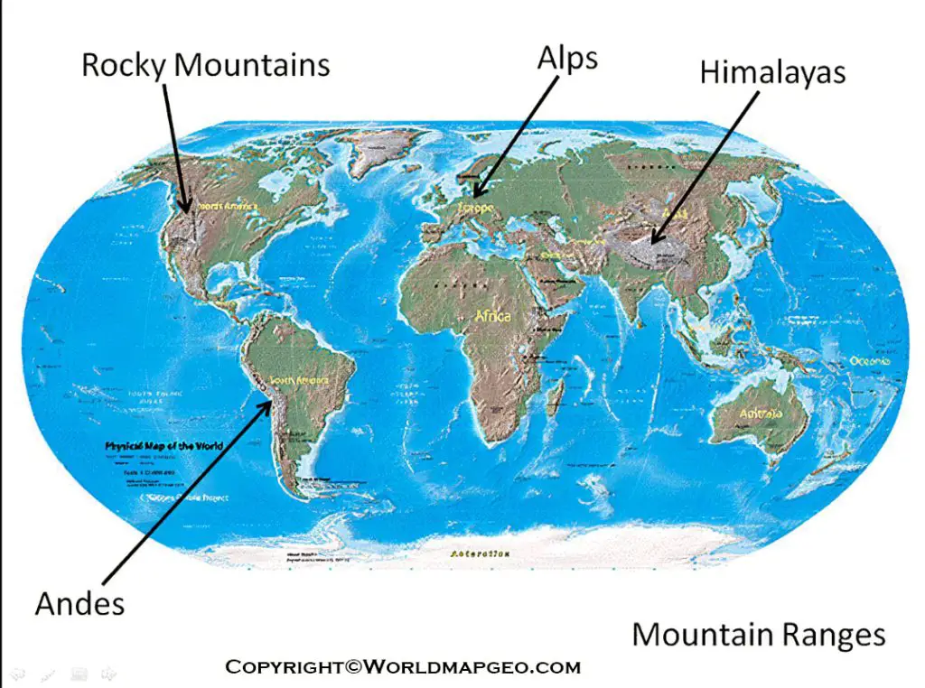
Furthermore, researchers and environmentalists can use the labeled mountain ranges map to study the impact of climate change, land degradation, and human activities on these sensitive ecosystems. By precisely identifying mountain ranges and their surrounding environments, scientists can monitor changes over time and develop conservation strategies to protect these fragile landscapes.
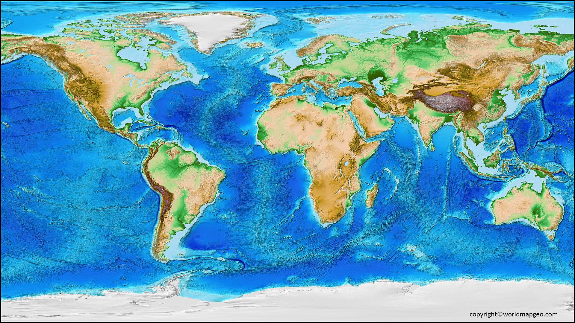
World Map with Mountain Ranges
A world map with mountain ranges provides a unique and visually striking representation of Earth’s topography. Unlike conventional maps, this cartographic masterpiece places a special emphasis on mountain systems, showcasing them in vibrant colors or shaded relief to make them stand out prominently against the surrounding terrain.
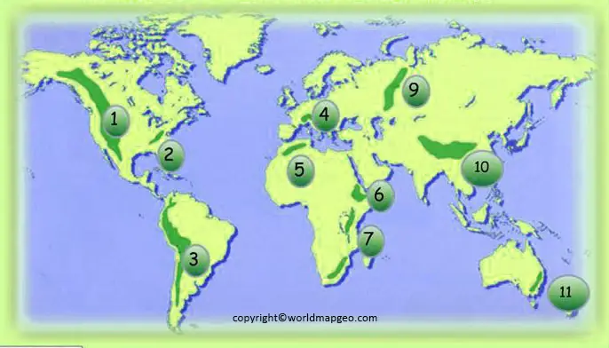
The map highlights the extensive distribution of mountain ranges across continents and showcases their interconnectedness. It allows viewers to discern how mountain ranges often form natural barriers, influencing weather patterns, and shaping the cultural and historical development of regions around the world.
With this map, individuals can grasp the enormity of the Himalayas, the expanse of the Andes, the rugged beauty of the Rockies, and the enchanting allure of the Alps—all in one captivating display. It serves as a testament to the unparalleled beauty and diversity of our planet’s landscape.
Beyond its aesthetic appeal, the world map with mountain ranges serves practical purposes. It helps geologists and researchers study the tectonic forces responsible for creating these magnificent formations, deepening our understanding of the Earth’s geological processes.
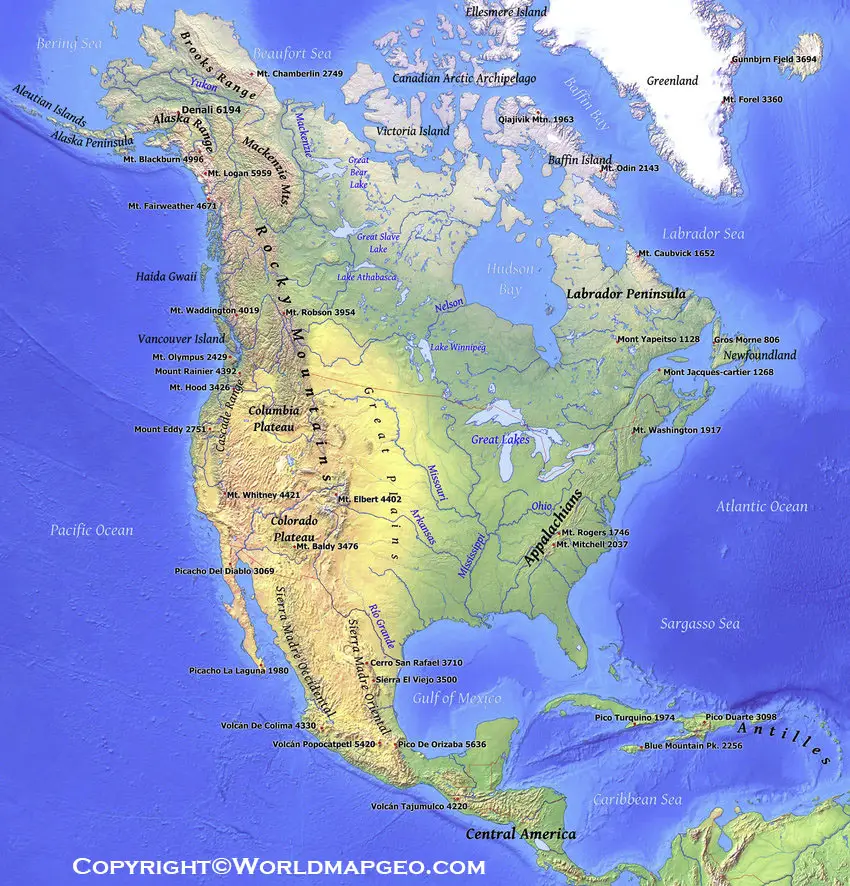
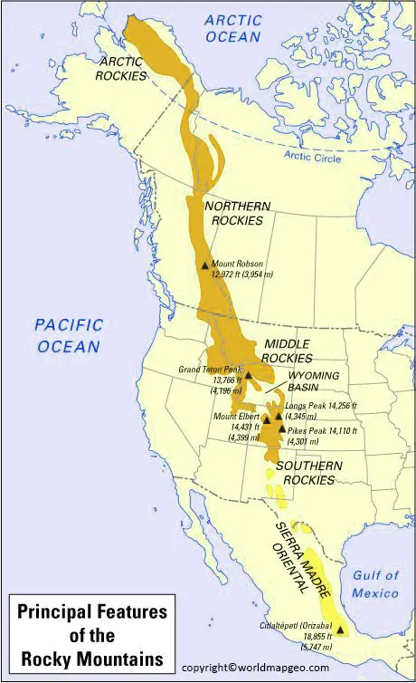
Rocky Mountain Range Map
The Rocky Mountain Range map is a specialized cartographic representation focusing solely on the Rocky Mountains, one of North America’s most iconic and rugged mountain systems. Stretching from Canada to the United States, the Rocky Mountains are renowned for their breathtaking scenery, abundant wildlife, and recreational opportunities.
This map delves into the specific geographic details of the Rocky Mountains, featuring major peaks, passes, national parks, and adjacent cities. It provides visitors and locals with essential information for planning outdoor adventures, such as hiking, camping, skiing, and mountaineering.
The Rocky Mountain Range map also highlights the region’s geological diversity, showcasing the contrast between jagged peaks, glacial valleys, and vast plateaus. Additionally, it delineates the Continental Divide, which runs along the Rockies and determines the direction of water flow across the continent.
For conservationists, this map is an invaluable tool in understanding the various ecosystems found within the Rocky Mountains. It pinpoints critical habitats for various plant and animal species, helping inform conservation efforts and promote sustainable land use practices.
Whether you’re an avid nature lover, a geology enthusiast, or a curious traveler, the Rocky Mountain Range map offers a captivating glimpse into the untamed beauty and geological significance of this awe-inspiring mountain system.
FAQs
1. Why are mountain ranges important?
Mountain ranges are essential because they provide freshwater, regulate climate, support biodiversity, generate hydroelectric power, and offer opportunities for tourism, recreation, and scientific research.
2. Which is the longest mountain range in the world?
The Andes Mountains in South America are the world’s longest continental mountain range, stretching approximately 7,000 kilometers (4,350 miles) along the western coast of the continent.
3. Which mountain range contains Mount Everest?
Mount Everest, the highest mountain on Earth, is located in the Himalayas on the border between Nepal and the Tibet Autonomous Region of China.
4. How are mountain ranges formed?
Most mountain ranges form when tectonic plates collide, causing the Earth’s crust to fold and rise. Others are created through volcanic activity, faulting, or long-term erosion.