Ohio River Map: The Ohio River is the third-largest river by discharge volume in the US. It is 981 (1,557 km) miles long and located at the Midwestern and southern boundaries of the US. The Ohio River flows southwest from western Pennsylvania to the Mississippi River at the southern tip of Illinois.
It is also the 6th-oldest river in North America, flowing along the borders of 6 states, and the drainage includes 14 states. It is the largest tributary by volume of the North-south flowing Mississippi River,r dividing the eastern and western United States. The Ohio River serves as the source of drinking water for more than 5 million People.
Related Post –
- Blank Map of Serbia
- Blank Map of Seychelles
- Blank Map of Sierra Leone
- Blank Map of Singapore
- Blank Map of Slovakia
Ohio River Map
An Ohio River map is a valuable resource that provides essential information about one of the most significant rivers in the United States. The Ohio River stretches approximately 981 miles (1,579 kilometers) and is the largest tributary of the Mississippi River. It originates from the confluence of the Allegheny and Monongahela rivers in Pittsburgh, Pennsylvania, and flows southwestward, forming the boundary between Ohio and several neighboring states.
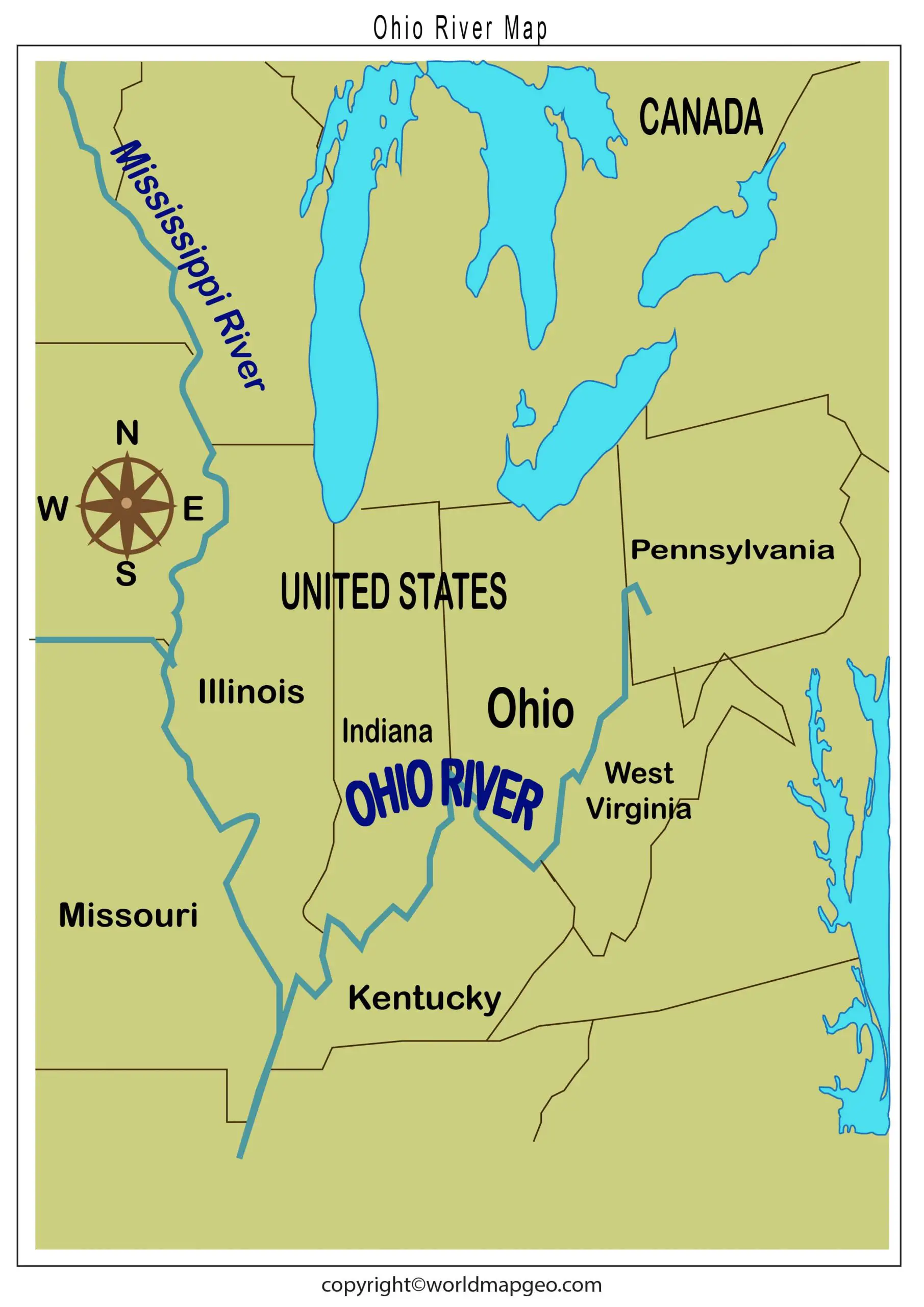
On the map, you can trace the course of the Ohio River through six states: Pennsylvania, Ohio, West Virginia, Kentucky, Indiana, and Illinois. The river serves as a crucial transportation route and has played a pivotal role in the historical and economic development of the region. Many major cities, such as Cincinnati, Louisville, and Pittsburgh, have thrived along its banks, owing much of their growth to the river’s navigational advantages.
In addition to its economic significance, the Ohio River also holds immense ecological importance. The river and its surrounding wetlands provide habitat for a diverse range of plant and animal species, contributing to the rich biodiversity of the region. Preservation efforts have been initiated to protect the river’s natural ecosystems and ensure its sustainable use for future generations. Check out other River Maps:- Rio Grande River Map, World River Map, Danube River Map.
Understanding an Ohio River map can also aid in planning recreational activities along its shores. The river offers numerous opportunities for boating, fishing, camping, and birdwatching. Various parks and green spaces line its banks, providing a peaceful retreat from the bustling city life. Whether for educational purposes or recreational planning, an Ohio River map is an essential tool for locals and visitors alike.
Ohio River on Map
The Ohio River, one of the most significant waterways in the United States, is a prominent feature on maps due to its size, historical importance, and impact on regional trade and transportation. Stretching approximately 981 miles (1,579 kilometers), the Ohio River flows through or forms the boundary of six states: Illinois, Indiana, Kentucky, Ohio, Pennsylvania, and West Virginia. It is a tributary of the Mississippi River, with which it merges near Cairo, Illinois. The river’s source can be traced back to Pittsburgh, Pennsylvania, where the Allegheny and Monongahela Rivers converge.
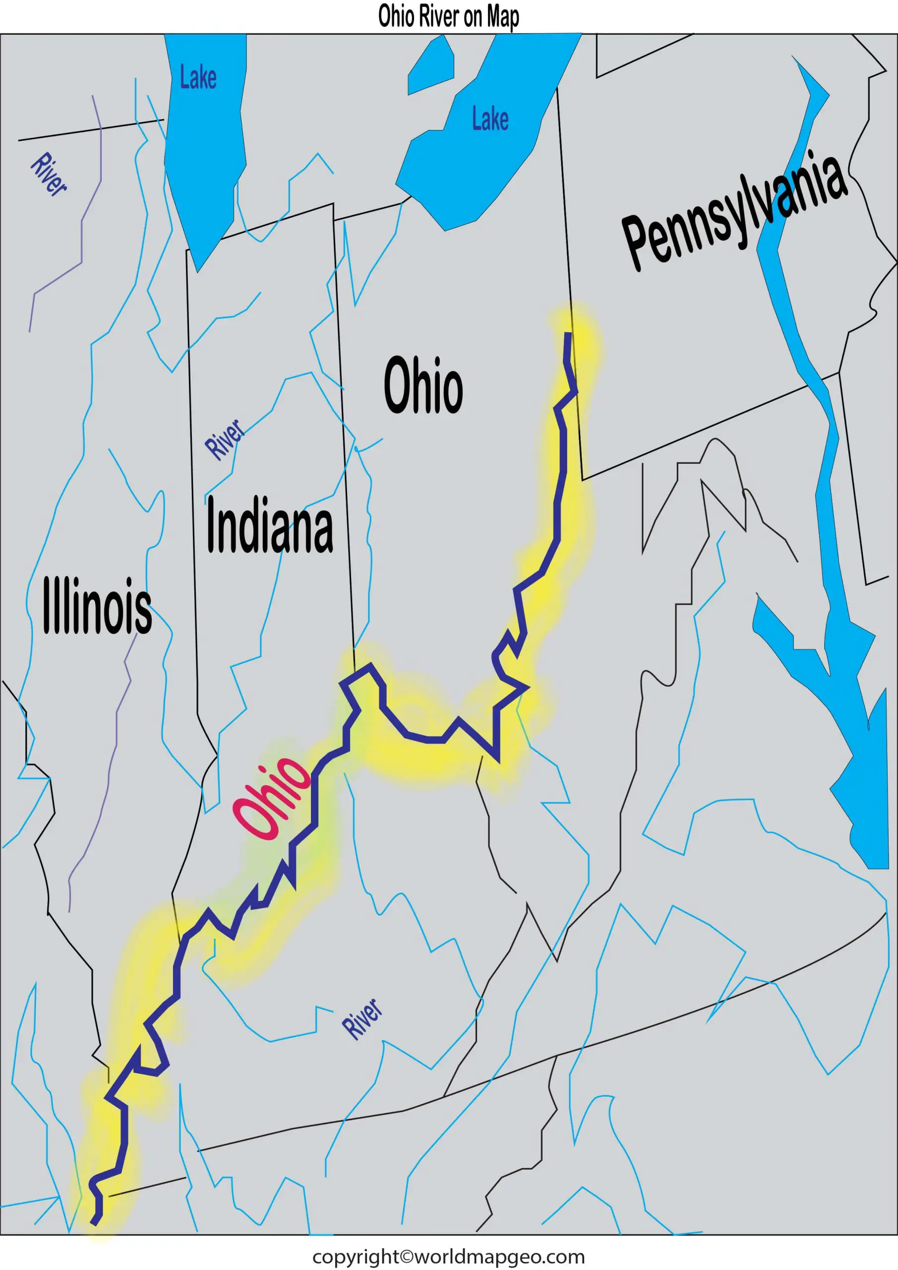
On a map, the Ohio River is easy to identify due to its long, sinuous shape. It meanders through the heart of the eastern United States, passing through various cities and towns, and serving as a natural boundary between states in certain regions. The river’s width can vary significantly along its course, with broader sections allowing for significant barge traffic and supporting vital trade routes between the Midwest and the Gulf of Mexico. Additionally, numerous bridges spanning the river further emphasize its presence on maps and highlight the importance of these crossing points in connecting communities.
Tourists and history enthusiasts often reference maps to explore the Ohio River’s scenic beauty and its connections to the rich cultural heritage of the region. From the historic river towns with their well-preserved architecture to the lush greenery along the riverbanks, the Ohio River offers a captivating landscape for travelers and locals alike. With many recreational activities available, including boating, fishing, and hiking, the river remains a cherished destination for outdoor enthusiasts who wish to immerse themselves in the natural wonders of the Midwest.
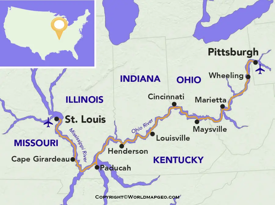
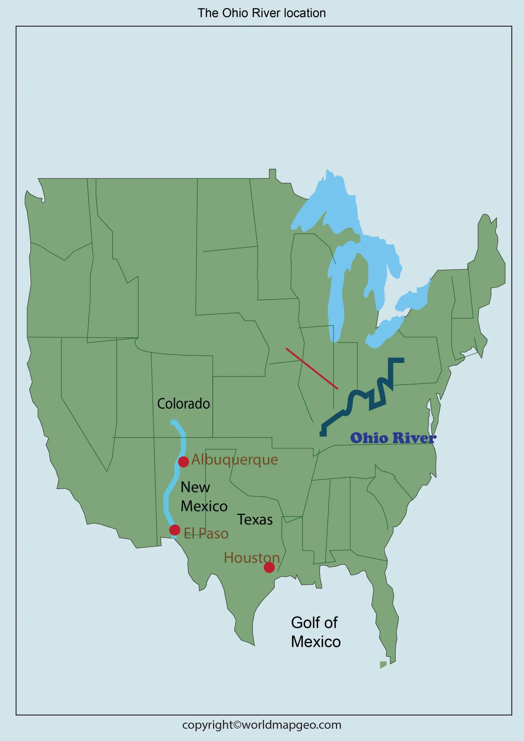
Where is the Ohio River Located on a Map?
The Ohio River, a vital watercourse in the United States, can be located on a map within the central-eastern region of the country. As a major tributary of the Mississippi River, it traverses six states, making it easily identifiable on most U.S. maps. Its journey begins at the confluence of the Allegheny and Monongahela Rivers in Pittsburgh, Pennsylvania. From there, it flows southwestward, forming part of the borders between Ohio and West Virginia, Ohio and Kentucky, and Illinois and Kentucky. The river also flows through Indiana and touches the southwestern tip of Illinois before joining the Mississippi River near Cairo, Illinois.
On a more detailed map, one can observe the intricate network of rivers and streams that contribute to the Ohio River’s watershed. Various topographical features, such as mountains and valleys, have played a crucial role in shaping the river’s path over time. Additionally, cities like Cincinnati, Louisville, and Pittsburgh stand out as major urban centers along the Ohio River, adding further context ttheirts location and significance.
Aside from serving as a natural boundary between states, the Ohio River has been instrumental in shaping the historical development of the regions it passes through. The fertile lands surrounding the river have supported agriculture and industry, contributing to the growth of cities and the expansion of trade networks. Today, the Ohio River remains a vital waterway for commerce and transportation, with barges carrying goods along its length and connecting the Midwest to international markets.
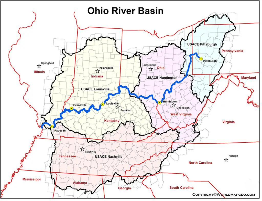
Ohio River State-wise Flow
The Ohio River flows through or along the borders of six U.S. states before joining the Mississippi River. It begins in the eastern part of the United States and generally flows in a westward direction.
1. Pennsylvania (Starting Point)
The source of the Ohio River is in Pittsburgh, PA. This is where the Allegheny and Monongahela Rivers come together to create the Ohio River. From here, it begins its trip.
2. West Virginia
The river then heads out of Pittsburgh and meanders along the West Virginia border. It is a natural boundary that borders West Virginia and other states in many places.
3. Ohio
The river then forms the southern border of the state of Ohio. Several towns and cities are located along this stretch, making it an important regional waterway.
4. Kentucky
The Ohio River flows west and forms the long border between Ohio and Kentucky. It’s a stretch of the river that’s the longest in terms of continuous stretch.
5. Indiana
Along the northern side of the river, it also borders Indiana. Here, it continues to serve as a natural dividing line between Indiana and Kentucky.
6. Illinois (Ending Point)
The river then ends at Cairo, Illinois, where it flows into the Mississippi River. This point marks the end of the Ohio River’s journey.
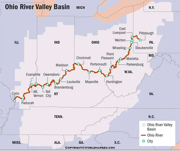
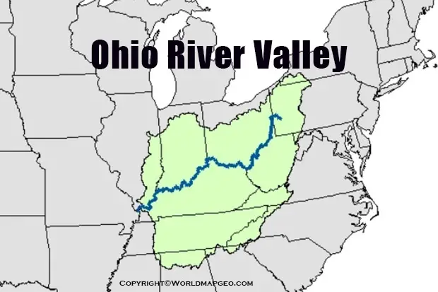
Ohio River Valley Map
The Ohio River Valley is a region of great historical and ecological importance, and it can be explored and understood better through a dedicated map. Extending along the banks of the Ohio River and its surrounding tributaries, the valley encompasses parts of several states in the eastern United States. These states include Ohio, Kentucky, Indiana, and portions of Illinois, Pennsylvania, and West Virginia.
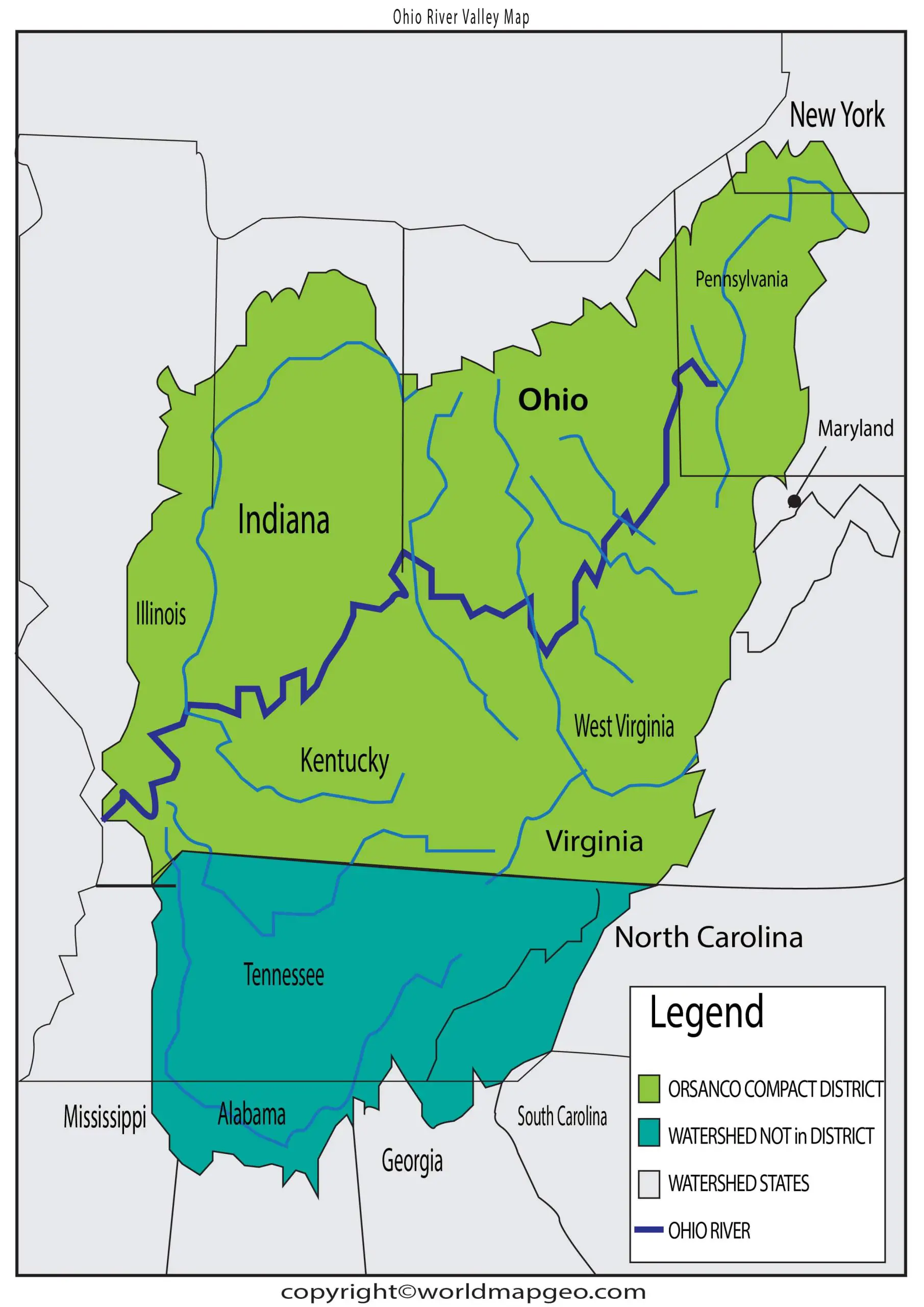
A map of the Ohio River Valley would showcase not only the main stem of the river but also its various branches and connecting waterways. The valley is characterized by its fertile floodplains, which have historically supported thriving agricultural communities. On the map, one can trace the flow of the Ohio River, passing by cities and towns like Cincinnati, Louisville, and Pittsburgh, which have played essential roles in the region’s development and history.
The Ohio River Valley has been a significant cultural crossroads for indigenous peoples and later European settlers. Exploring the region’s history and diverse heritage can be facilitated through a map, where markers of important historical sites, battlefields, and archaeological discoveries are noted. Additionally, the valley’s natural beauty is a highlight on the map, with national parks, wildlife reserves, and scenic areas providing recreational opportunities and preserving the area’s ecological integrity.
Maps of the Ohio River Valley may also include information about industries that have thrived in the region, such as manufacturing, coal mining, and agriculture. Understanding the economic activities of the valley adds another layer of insight into its significance and ongoing development.
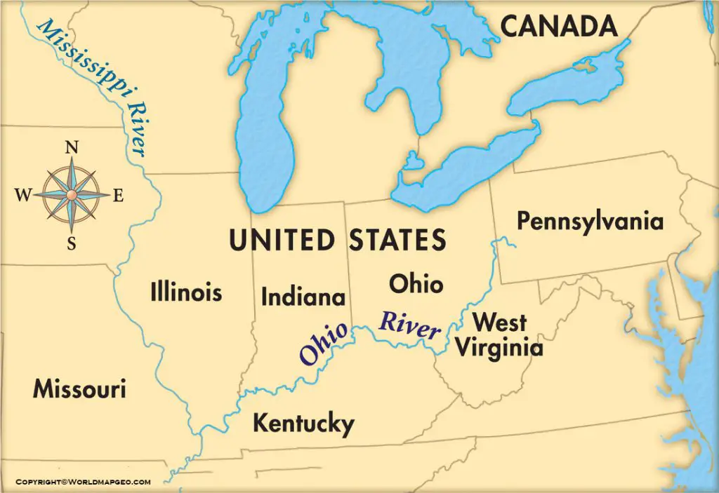
Ohio River Map USA
An Ohio River map in the context of the entire United States would demonstrate the river’s vast extent and its integral role in the country’s transportation and trade networks. As one of the principal rivers in the U.S., the Ohio River is prominently featured on national maps and atlases. It serves as a critical connector, linking the Midwest to the Gulf of Mexico via the Mississippi River.
On a U.S. map, the Ohio River can be traced from its source in Pittsburgh, Pennsylvania, and followed as it meanders through several states. Starting in the eastern part of the country, the river flows southwest, forming natural borders between states such as Ohio and West Virginia, Ohio and Kentucky, and Indiana and Kentucky. Eventually, it reaches the southernmost tip of Illinois, where it converges with the Mississippi River near Cairo, Illinois.
The Ohio River’s strategic location has made it a significant transportation route since the early days of American history. On the map, one can observe the numerous cities and towns that have sprung up along its banks, drawing economic prosperity from the river’s resources and fostering trade and commerce.
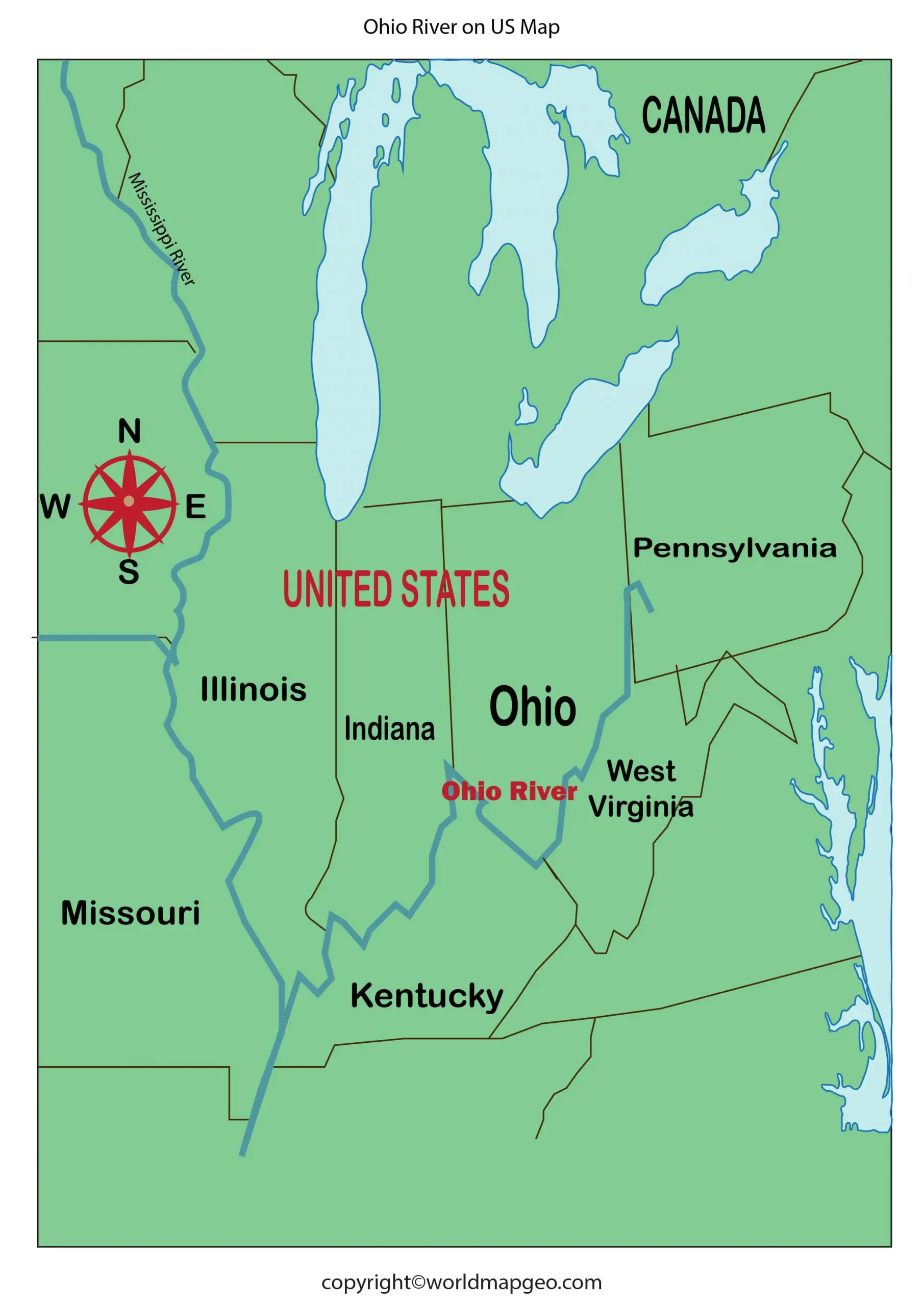
Furthermore, an Ohio River map in the context of the United States would highlight other waterways that contribute to its extensive watershed. Various tributaries feed into the Ohio River, draining vast regions and adding to its flow. Additionally, dams and locks along the river allow for improved navigation and flood control, all of which are relevant details depicted on the map.
FAQs
1. What is an Ohio River Map?
An Ohio River Map is a map of the states, cities, and regions the Ohio River flows through from its source to its mouth.
2. Which states are shown in the Ohio River Map?
The map indicates that the river runs through the states of Pennsylvania, West Virginia, Ohio, Kentucky, Indiana, and Illinois.
3. What does an Ohio River Map help to understand?
Understanding the route of the river, nearby states, big cities, tributaries, and its connection to the Mississippi River system.
4. Where does the Ohio River start and end on the map?
On the map, the Ohio River starts at Pittsburgh, Pennsylvania, and ends at Cairo, Illinois, where it meets the Mississippi River.
5. Why is the Ohio River Map important for students?
It is essential for teaching geography, U.S. river systems, state boundaries, and transport/travel routes.