This article is about the information of the Danube River map with all its special features. The Danube is the second-longest river in Europe and runs through ten countries. It begins in the Black Forest of Germany and flows southeast for 2,857 miles before emptying into the Black Sea. Along its journey, the Danube passes through major European cities like Vienna, Budapest, and Belgrade. The river is a popular tourist destination for cruises and riverboat rides. Danube River Map Europe have been available here in Pdf
Quick Facts About the Danube River
| Feature | Details |
|---|---|
| Length | Approximately 2,857 km (1,775 miles) |
| Source | Donaueschingen, Black Forest, Germany |
| Mouth | Danube Delta, Romania and Ukraine (Black Sea) |
| Countries Flowed Through | Germany, Austria, Slovakia, Hungary, Croatia, Serbia, Romania, Bulgaria, Moldova, Ukraine |
| Drainage Basin Area | About 817,000 km² (315,000 sq mi) |
| Average Discharge | Around 6,500 m³/s at the Black Sea |
| Major Tributaries | Inn, Drava, Tisza, Sava, Morava, Prut |
| Major Dams | Gabčíkovo Dam, Iron Gate I, Iron Gate II |
| Largest Cities on the River | Vienna, Bratislava, Budapest, Belgrade |
Related Post:
- Blank Map of Luxembourg
- Blank Map of Monaco
- Blank Map of Liechtenstein
- Blank Map of Bhutan
- Blank Map of Bolivia
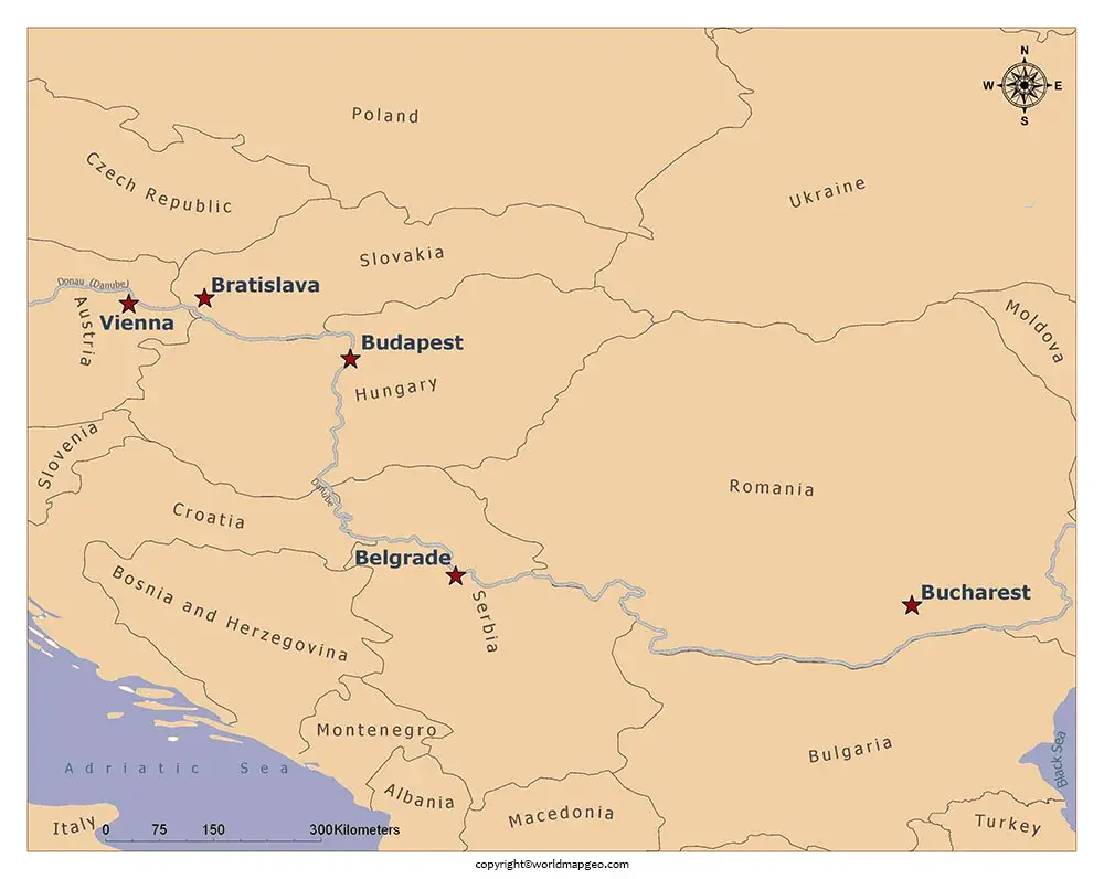
Danube River map
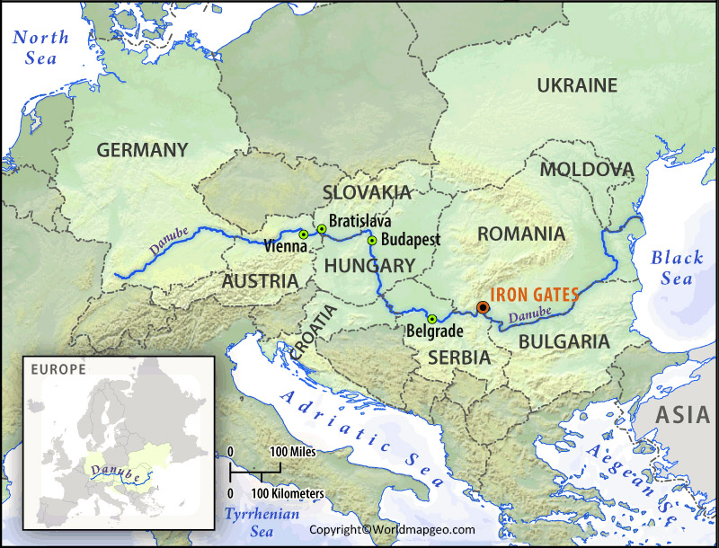
The Danube River, known as the “Queen of Europe’s Rivers,” is a prominent waterway that flows through several countries in Central and Eastern Europe. A Danube River map provides a visual representation of this iconic river and its surrounding regions. Starting in Germany’s Black Forest, the Danube travels through or forms a border with countries such as Austria, Slovakia, Hungary, Croatia, Serbia, Bulgaria, and Romania before emptying into the Black Sea.
A detailed Danube River map highlights notable cities and landmarks along its course. These include Vienna in Austria, Budapest in Hungary, Belgrade in Serbia, and the stunning Danube Delta in Romania. The map may also indicate important tributaries that join the Danube, such as the Sava, Drava, and Tisza rivers.
With its historical significance and scenic beauty, the Danube River is a popular destination for river cruises, offering travelers an opportunity to explore multiple countries and experience diverse cultures. The map can serve as a useful tool for planning such journeys, indicating docking points, major ports, and attractions along the way.
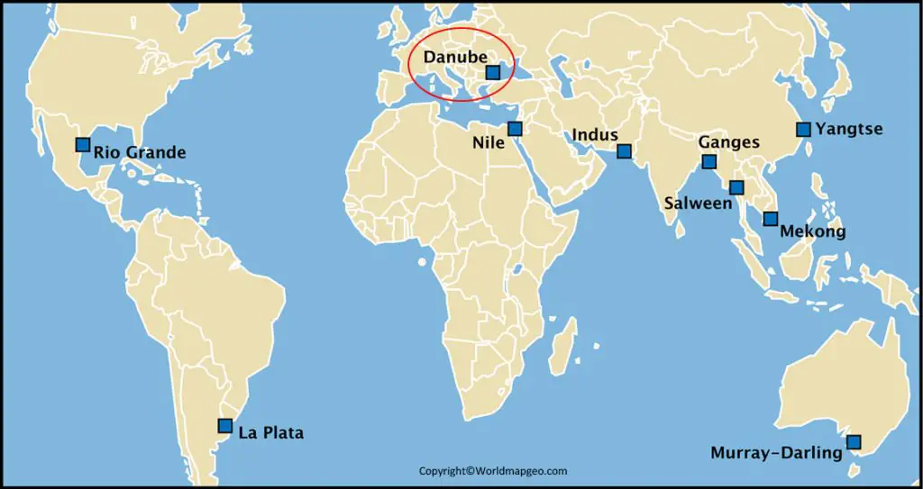
Furthermore, a Danube River map may feature natural landmarks and protected areas, such as the Iron Gates gorge, Wachau Valley, and the Danube-Ipoly National Park, highlighting the river’s ecological importance. Check out other River Maps:- Missouri River Map, Nile River Map, Colorado River Map.
Overall, a Danube River map is an invaluable resource for adventurers, tourists, and geography enthusiasts alike, providing a glimpse into the splendor and significance of this remarkable European waterway.
Danube River on Map
The Danube flows through ten countries: Romania, Bulgaria, Moldova, Ukraine, Slovakia, Hungary, Croatia, Serbia, Montenegro and Bosnia and Herzegovina. The river is a major transport route for goods and people between these countries. It is also an important source of water for industry and agriculture. The map below shows the Danube river in all its glory. You can see how it winds its way through Europe.
The Danube River is the second longest river in Europe, after the Volga. It originates in the Black Forest of Germany and flows for a total of 2,860 kilometers through ten countries before emptying into the Black Sea. The Danube is an important waterway for trade and transportation and is also a popular tourist destination. The river flows through some of Europe’s most beautiful scenery, including the Bavarian Alps, the Vienna Woods, and the Iron Gates gorge.
Beyond the urban landscapes, the Danube River map also showcases the stunning natural beauty that surrounds the river. From the breathtaking Wachau Valley in Austria to the awe-inspiring Iron Gates Gorge between Serbia and Romania, the Danube weaves its way through captivating scenery. Lush vineyards, rolling hills, and rugged cliffs add to the river’s charm, making it a popular destination for river cruises, cycling tours, and outdoor enthusiasts.
Map of Danube River
The Danube has long been an important waterway for trade and transportation. In ancient times, it was used by the Romans to transport troops and supplies. Today, it is still an important route for shipping goods between countries in Europe. The Danube is navigable from its mouth up to the city of Vienna.
The first written record of the name Danube comes from the Greek historian Herodotus who called it Ister. The Danube River is not only a physical landmark but also a symbol of European history, cultural diversity, and natural beauty. Its economic, social, and ecological importance cannot be overstated. Understanding and appreciating the Danube River helps us recognize the interconnectedness of European nations and the need to protect and preserve this invaluable resource for future generations.
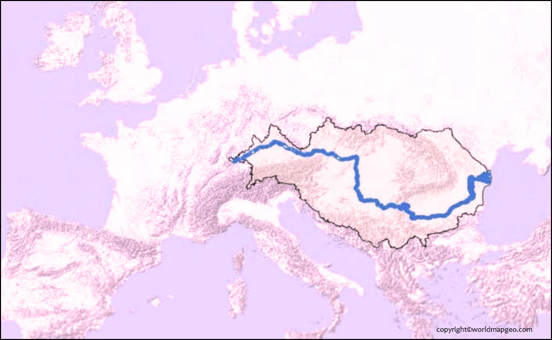
The Danube River, one of Europe’s most iconic waterways, winds its way through ten countries, making it the second longest river in the continent. A map of the Danube River provides a visual representation of its route, stretching from its source in Germany’s Black Forest to its vast delta in the Black Sea.
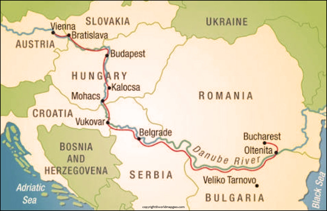
As you trace the course of the Danube on the map, you’ll discover the diverse landscapes it traverses. The river passes through countries such as Germany, Austria, Slovakia, Hungary, Croatia, Serbia, Bulgaria, and Romania, connecting numerous historic cities and cultural centers along its banks.
The map highlights key destinations along the Danube, including Vienna, Budapest, Bratislava, and Belgrade. These cities offer a rich blend of history, architecture, and vibrant cultural experiences. From exploring ancient castles and fortresses to strolling along picturesque waterfront promenades, each stop along the Danube promises unique encounters and unforgettable memories.
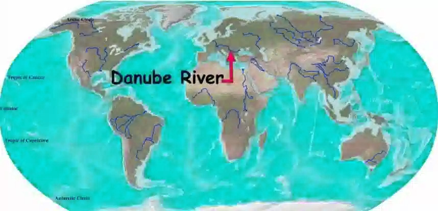
Danube River on World Map
The Danube is the second longest river in Europe and provides an important route for trade and transportation. The river begins in Germany and flows through ten countries before emptying into the Black Sea. Despite its importance, navigation on the Danube has been hampered by low water levels, environmental concerns, and political tensions between countries.
The river has been an important part of European history and has been featured in many works of art and literature. Europe’s second longest river, the Danube flows for 1,788 miles through 10 countries before emptying into the Black Sea. As it winds its way through Europe, the Danube picks up nutrients and pollutants from the land along its banks. These substances can have a major impact on the river’s ecosystem.
The Danube River ecosystem is home to a variety of plants and animals. For example, the common reed is an important plant species in the Danube’s wetlands. Here we will explore the relationship between the Rhine and Danube Rivers, how they have interacted over time, and their importance to Europe today.
Where is the Danube River located on a Map
The Danube River is located in Central and Eastern Europe and is one of the continent’s major waterways. Stretching approximately 2,850 kilometers (1,770 miles), the Danube flows through ten countries, making it the second-longest river in Europe after the Volga.
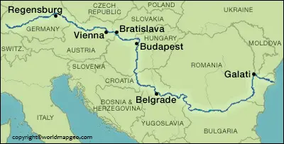
On a map, you can trace the Danube River as it winds its way through countries such as Germany, Austria, Slovakia, Hungary, Croatia, Serbia, Bulgaria, Romania, Moldova, and Ukraine. It originates in the Black Forest of Germany and flows southeastward, eventually emptying into the Black Sea.
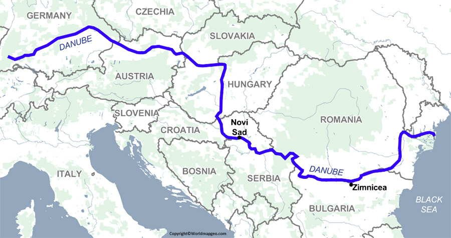
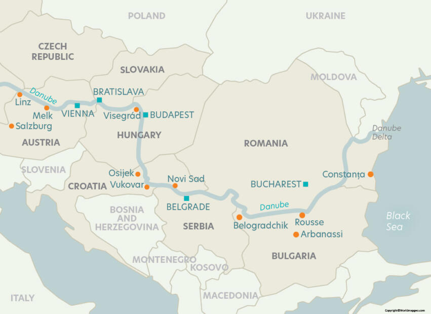
Throughout its course, the Danube passes through numerous iconic cities, including Regensburg, Vienna, Budapest, Belgrade, and Bucharest. These cities not only offer stunning river views but also boast rich history, vibrant culture, and architectural wonders.
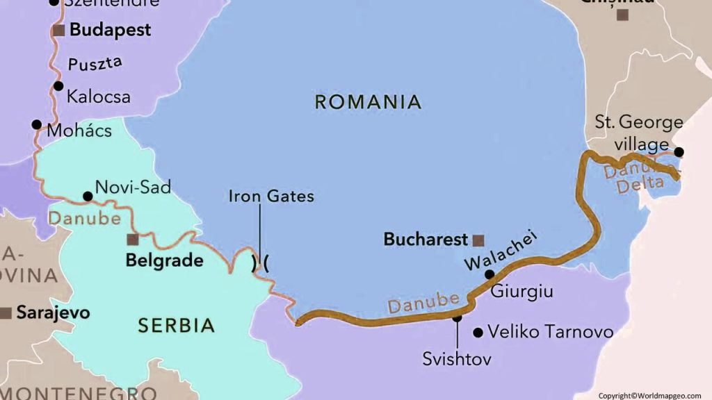
Mapping the Danube River allows you to appreciate the diverse landscapes it traverses, from the picturesque countryside of Germany and Austria to the stunning Danube Bend in Hungary and the serene Iron Gates gorge between Serbia and Romania.
The Danube River is one of the most popular tourist destinations in Europe. Every year, millions of people come to the river to enjoy its many water activities. The river is perfect for swimming, fishing, kayaking, and more. With so much to do, it’s no wonder the Danube River is one of the most popular tourist destinations in Europe. The Danube has many different kinds of fish, including carp, pike, salmon, and sturgeon.
The Rhine and Danube rivers are two of the most important waterways in Europe. The Rhine River originates in the Swiss Alps and flows through Germany, the Netherlands, and Belgium before emptying into the North Sea. These two rivers have had a long and complicated history, with both playing significant roles in the development of Europe.
Rhine and Danube River map
The Rhine and Danube Rivers are two iconic waterways in Europe that have played significant roles in shaping the continent’s history, culture, and commerce. A Rhine and Danube River map provides a visual guide to these majestic rivers and their surrounding regions.
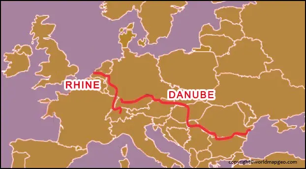
The Rhine River flows through several countries, including Switzerland, Germany, France, and the Netherlands. It passes by vibrant cities like Basel, Strasbourg, Cologne, and Amsterdam. The map would highlight key landmarks along the Rhine, such as the Rhine Gorge with its famous Lorelei rock, the charming wine villages of the Upper Middle Rhine Valley (a UNESCO World Heritage site), and the bustling port of Rotterdam where the river meets the North Sea.
The Danube River, often referred to as Europe’s second-longest river, winds its way through countries such as Germany, Austria, Slovakia, Hungary, and Romania, before reaching the Black Sea. The map would showcase cities like Passau, Vienna, Budapest, and Belgrade, which are all rich in history, architecture, and cultural heritage. The Danube also passes through the stunning Wachau Valley, known for its vineyards, castles, and picturesque landscapes.
A Rhine and Danube River map would provide travelers with an overview of the navigable sections, locks, and connecting waterways, making it easier to plan river cruises, scenic drives along riverbanks, or even cycling trips along dedicated paths.
Exploring the Rhine and Danube Rivers offers a unique opportunity to immerse oneself in Europe’s diverse cultures, witness breathtaking scenery, and visit iconic landmarks. Whether you’re interested in historical sites, vibrant cities, or simply admiring the natural beauty of these rivers, a map of the Rhine and Danube is an invaluable tool for creating unforgettable travel experiences.
Danube Bend (Hungary)
The Danube Bend is a scenic curve of the river in northern Hungary, near the historic town of Visegrád. Here, the river changes direction dramatically, creating one of the country’s most picturesque landscapes.
Popular attractions include:
- Visegrád Citadel
- Royal Palace of Visegrád
- Danube Bend panoramic viewpoints
- Hiking trails
- River cruises
- Historic villages such as Szentendre and Esztergom
The Danube Bend is one of Hungary’s top tourist destinations and is especially popular for day trips from Budapest.
Frequently Asked Questions
1. Which countries does the Danube River flow through?
The Danube flows through or forms borders with 10 countries: Germany, Austria, Slovakia, Hungary, Croatia, Serbia, Romania, Bulgaria, Moldova, and Ukraine.
2. Where does the Danube River start and end?
The Danube begins in Donaueschingen, Germany, and ends at the Danube Delta, where it flows into the Black Sea between Romania and Ukraine.
3. Is the Danube longer than the Rhine?
Yes. The Danube is approximately 2,857 km long, making it much longer than the Rhine, which is about 1,230 km long.
4. What is the largest city on the Danube River?
Budapest, the capital of Hungary, is the largest city located directly on the Danube River.
5. Why is the Danube Delta famous?
The Danube Delta is famous for its rich biodiversity, extensive wetlands, thousands of plant and animal species, and its designation as a UNESCO World Heritage Site.