The Nile River is one of the most famous rivers in the world and has played a central role in the development of human civilization for thousands of years. Flowing through northeastern Africa, the Nile has supported agriculture, transportation, trade, and settlements since ancient times. A Nile River map helps students, researchers, travelers, and geography enthusiasts understand the river’s route, the countries it passes through, its major tributaries, and its importance to the people who depend on it.
Stretching for approximately 6,650 kilometers (4,130 miles), the Nile is among the longest rivers on Earth. It begins in East Africa and flows northward before emptying into the Mediterranean Sea. Along its journey, the river crosses diverse landscapes, including tropical forests, wetlands, savannas, deserts, and fertile floodplains.
A detailed Nile River map clearly illustrates the river’s course, showing important cities, lakes, dams, tributaries, and the countries connected by this remarkable waterway.
In this comprehensive guide, you’ll learn everything about the Nile River Map, including its geography, history, major features, ecological significance, printable map options, and fascinating facts.
The Nile River is a major river in northeastern Africa that has supported civilizations for more than 5,000 years. It is widely recognized for its historical importance to Ancient Egypt and remains one of Africa’s most valuable natural resources.
The river supplies fresh water to millions of people and supports agriculture, hydroelectric power generation, transportation, fishing, and tourism.
Because much of northeastern Africa is arid or semi-arid, the Nile serves as a lifeline for the countries it flows through.
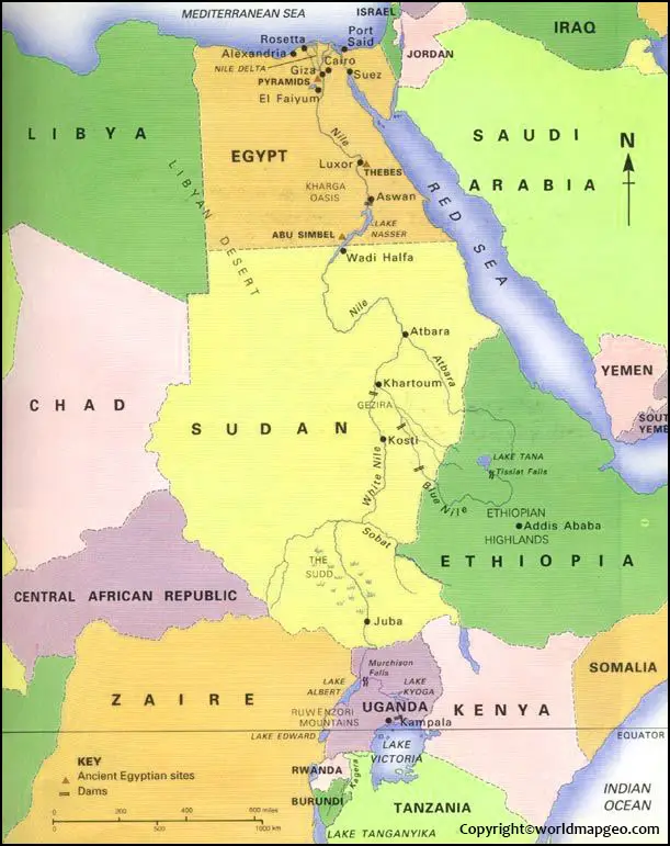
Nile River Quick Facts
| Feature | Information |
|---|---|
| River Name | Nile River |
| Length | Approximately 6,650 km (4,130 miles) |
| Continent | Africa |
| Flows Into | Mediterranean Sea |
| Main Tributaries | White Nile, Blue Nile, Atbara River |
| Major Countries | Uganda, South Sudan, Sudan, Egypt |
| River Basin Area | Approximately 3.4 million square kilometers |
| Direction of Flow | South to North |
Where Is the Nile River Located?
The Nile River is located in northeastern Africa and forms one of the world’s largest river systems. It flows through a vast region that includes tropical highlands, wetlands, grasslands, and deserts before reaching the Mediterranean coast.
The river is unique because it flows from south to north, which is the opposite direction of many of the world’s major rivers. This northward flow is determined by the gradual decrease in elevation from the East African highlands to the Mediterranean Sea.
The Nile Basin covers approximately 10% of Africa’s land area, making it one of the continent’s most significant drainage systems.
Nile River Map Overview
A Nile River map shows the complete journey of the river from its headwaters to its mouth.
Most detailed maps include:
- Source of the Nile
- Lake Victoria
- White Nile
- Blue Nile
- Atbara River
- Major lakes
- National borders
- Capital cities
- Major dams
- Reservoirs
- River delta
- Mediterranean Sea
Educational maps may also display elevation, climate zones, and population centers along the river.
Countries Through Which the Nile River Flows
The Nile River system connects multiple African countries, making it an important international water resource.
The primary countries directly along the main river include:
| Country | Importance |
|---|---|
| Uganda | White Nile begins near Lake Victoria |
| South Sudan | Large wetlands and river systems |
| Sudan | Confluence of the White and Blue Nile in Khartoum |
| Egypt | Agriculture, cities, and the Nile Delta |
The broader Nile Basin also includes:
- Ethiopia
- Kenya
- Tanzania
- Rwanda
- Burundi
- Democratic Republic of the Congo
- Eritrea (in some basin definitions)
These countries contribute water through tributaries and rainfall within the basin.
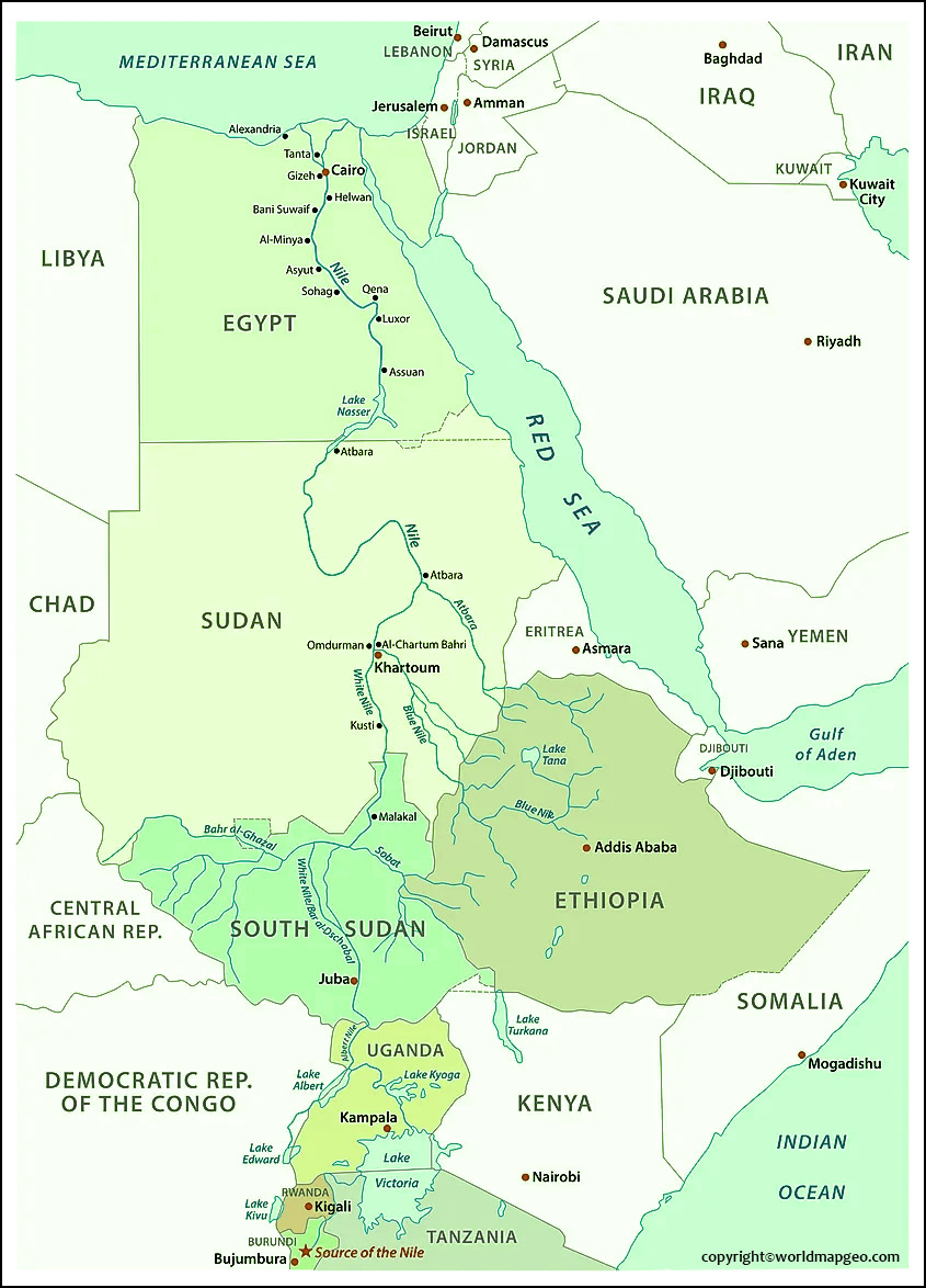
Source of the Nile River
The question of the Nile’s source has fascinated explorers for centuries.
Today, the river is generally understood to have two principal headwater systems:
White Nile
The White Nile originates from the Great Lakes region of East Africa, with Lake Victoria serving as its primary reservoir. Rivers feeding Lake Victoria extend into countries such as Burundi and Rwanda, making the overall source system complex.
Blue Nile
The Blue Nile begins at Lake Tana in the Ethiopian Highlands. Although shorter than the White Nile, it contributes a significant portion of the Nile’s water during the rainy season.
Together, these two rivers form the main Nile at Khartoum, Sudan.
Mouth of the Nile River
The Nile River ends at the Mediterranean Sea through the Nile Delta in northern Egypt.
The delta is:
- One of the world’s largest river deltas
- Highly fertile
- Densely populated
- Important for agriculture
- Rich in biodiversity
The Nile Delta has supported farming communities since ancient times and remains a vital food-producing region.
White Nile vs Blue Nile
The Nile’s two main branches have different characteristics.
| Feature | White Nile | Blue Nile |
|---|---|---|
| Source | Great Lakes Region (Lake Victoria system) | Lake Tana, Ethiopia |
| Water Flow | More consistent year-round | Seasonal, influenced by rainfall |
| Length | Longer | Shorter |
| Main Contribution | Steady base flow | Significant floodwater and sediment |
| Joins At | Khartoum | Khartoum |
The meeting point of these rivers in Khartoum is one of the most important geographical features shown on a Nile River map.
Major Tributaries of the Nile River
Several rivers feed the Nile and contribute to its overall flow.
Important tributaries include:
- White Nile
- Blue Nile
- Atbara River
- Sobat River
- Bahr el Ghazal River
Each tributary plays a role in maintaining the river’s water levels and supporting ecosystems across the basin.
Nile River Basin
The Nile River Basin is the area of land where rainfall drains into the Nile and its tributaries.
It covers parts of 11 African countries and supports more than 250 million people through agriculture, drinking water, fishing, transportation, and energy production.
The basin includes:
- Forests
- Wetlands
- Savannas
- Highlands
- Deserts
- Floodplains
Because many countries share the basin, cooperative water management is important for sustainable development.
Physical Features of the Nile River
The Nile passes through a variety of landscapes, each with unique environmental characteristics.
Major Physical Features
- Great Lakes region
- Sudd wetlands in South Sudan
- Ethiopian Highlands
- Nubian Desert
- Nile Valley
- Nile Delta
- Mediterranean coastline
These diverse environments make the Nile one of the world’s most ecologically significant river systems.
Historical Importance of the Nile River
The Nile River is often called the “Gift of the Nile,” a phrase attributed to the ancient Greek historian Herodotus.
Ancient Egypt depended on the Nile for:
- Irrigation
- Drinking water
- Transportation
- Trade
- Fishing
- Agriculture
- Religious ceremonies
Seasonal flooding deposited nutrient-rich silt on surrounding land, enabling successful farming and supporting one of history’s greatest civilizations.
Today, the river continues to play a crucial role in the economies and daily lives of millions of people across northeastern Africa.
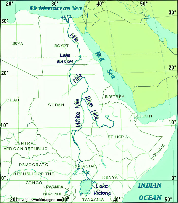
Why Is the Nile River Important?
The Nile River supports numerous aspects of life and development across the region.
- Agriculture – Water from the Nile irrigates crops such as wheat, rice, cotton, sugarcane, vegetables, and fruits.
- Drinking Water – Millions of people rely on the Nile as a primary source of freshwater.
- Transportation – The river has long served as a transportation corridor for people and goods.
- Hydroelectric Power – Major dams along the Nile generate electricity that powers homes, industries, and infrastructure.
- Tourism – Historic monuments, river cruises, archaeological sites, and natural landscapes attract visitors from around the world.
Major Cities Along the Nile River
The Nile River has supported human settlements for thousands of years. Today, many of Africa’s most important cities are located along its banks because of its reliable water supply, fertile land, and transportation opportunities.
A detailed Nile River map highlights these cities and their strategic locations.
Cairo, Egypt
Cairo is the largest city in Egypt and one of the largest metropolitan areas in Africa. Situated near the Nile Delta, it serves as the country’s political, economic, and cultural center.
Highlights
- Capital of Egypt
- Close to the Giza Pyramids
- Major transportation hub
- Important business center
- Home to millions of residents
Khartoum, Sudan
Khartoum is famous because it is the point where the White Nile and Blue Nile merge to form the main Nile River.
Highlights
- Capital of Sudan
- Meeting point of the two main tributaries
- Major trade and administrative center
- Educational and cultural hub
Jinja, Uganda
Jinja is often associated with the source region of the White Nile.
Highlights
- Located near Lake Victoria
- Popular for rafting and adventure tourism
- Important hydroelectric facilities
- Major tourist destination
Aswan, Egypt
Aswan is known for its rich history and the famous Aswan High Dam.
Attractions
- Aswan High Dam
- Philae Temple
- Nubian culture
- Nile cruises
- Lake Nasser
Luxor, Egypt
Luxor is often called the world’s greatest open-air museum.
Famous Sites
- Karnak Temple
- Luxor Temple
- Valley of the Kings
- Valley of the Queens
- Ancient Egyptian monuments
The Nile has played a central role in connecting these historic sites for centuries.
Wildlife of the Nile River
The Nile River supports a wide variety of wildlife and ecosystems.
From tropical wetlands to desert floodplains, the river provides habitats for thousands of plant and animal species.
Mammals
Some mammals found near the Nile include:
- Hippopotamus (primarily in upstream regions)
- African elephants (within parts of the basin)
- Antelopes
- Waterbucks
- Baboons
- Monkeys
- Warthogs
Birds
The Nile Basin is home to hundreds of bird species.
Popular examples include:
- African fish eagle
- Kingfisher
- Heron
- Egret
- Pelican
- Flamingo
- Stork
- Ibis
Many migratory birds also use the Nile as an important flyway.
Fish
The river supports both commercial and recreational fishing.
Common species include:
- Nile Perch
- Tilapia
- Catfish
- Tigerfish (in parts of the basin)
- Electric fish
Fishing remains an important source of food and income for many communities.
Reptiles
Some well-known reptiles include:
- Nile Crocodile
- Monitor lizards
- Turtles
- Various snake species
The Nile Crocodile is one of the largest freshwater reptiles in the world.
Plants Along the Nile
The river supports a wide range of vegetation.
Common plant life includes:
- Papyrus
- Date palms
- Acacia trees
- Reeds
- Water lilies
- Wetland grasses
- Agricultural crops
Historically, papyrus was used by Ancient Egyptians to produce writing material, boats, baskets, and other everyday items.
The Nile River Delta
The Nile Delta is one of the world’s largest river deltas and is located in northern Egypt, where the river flows into the Mediterranean Sea.
Features
- Fan-shaped landform
- Rich agricultural soil
- Dense population
- Extensive irrigation systems
- Wetlands and lagoons
Importance
The delta is essential for:
- Food production
- Fishing
- Transportation
- Biodiversity
- Economic development
It has been the agricultural heart of Egypt for thousands of years.
The Aswan High Dam
One of the most significant modern structures on the Nile is the Aswan High Dam, completed in the 20th century.
Purpose
- Flood control
- Electricity generation
- Water storage
- Irrigation support
- Drought management
Benefits
- Reliable water supply
- Increased agricultural productivity
- Hydroelectric power generation
- Improved navigation
Challenges
- Reduced natural sediment reaching the delta
- Environmental changes
- Altered fish migration patterns
Despite these challenges, the dam remains a cornerstone of Egypt’s water management strategy.
Lake Nasser
Behind the Aswan High Dam lies Lake Nasser, one of the world’s largest artificial lakes.
Facts
| Feature | Information |
|---|---|
| Type | Artificial Reservoir |
| Country | Egypt and Sudan |
| Created By | Aswan High Dam |
| Main Uses | Water storage, irrigation, electricity, fishing |
Lake Nasser plays a vital role in regulating the flow of the Nile.
Climate Along the Nile River
The climate changes significantly from the river’s source to its mouth.
- Tropical Climate – Near the Great Lakes region, the climate is warm and humid with abundant rainfall.
- Savanna Climate – Moving northward, the river passes through grasslands and seasonal rainfall zones.
- Desert Climate – In Sudan and Egypt, the Nile flows through arid deserts where rainfall is minimal and the river becomes the primary source of freshwater.
These climatic differences influence agriculture, wildlife, and human settlements along the river.
Agriculture Along the Nile
For thousands of years, the Nile has supported farming by providing fertile soil and dependable irrigation.
Major Crops
- Wheat
- Rice
- Cotton
- Sugarcane
- Corn
- Vegetables
- Fruits
- Legumes
Without the Nile, large-scale agriculture in Egypt and northern Sudan would be extremely difficult.
Economic Importance of the Nile River
The Nile contributes significantly to the economies of the countries within its basin.
Agriculture
Millions of farmers rely on the river for irrigation and crop production.
Fishing
The river supports local fisheries, providing food and employment.
Tourism
Tourists visit the Nile for:
- River cruises
- Ancient temples
- Archaeological sites
- Cultural experiences
- Scenic landscapes
Hydroelectric Power
Several dams generate electricity that supports homes, businesses, and industries.
Transportation
The river continues to facilitate the movement of people and goods in many regions.
Transportation on the Nile
The Nile has served as a transportation route for thousands of years.
Modern river transport includes:
- Passenger boats
- Cargo vessels
- Ferries
- Tourist cruise ships
- Traditional feluccas (sailboats)
River transport remains particularly important in areas where road infrastructure is limited.
Printable Nile River Maps
Printable maps are widely used by students, teachers, and researchers.
Popular formats include:
Political Nile River Map
Shows:
- Countries
- Borders
- Capitals
- Major cities
Physical Nile River Map
Displays:
- Mountains
- Lakes
- Tributaries
- Elevation
- Deserts
Blank Nile River Map
Ideal for:
- Geography assignments
- Classroom quizzes
- Educational worksheets
- Practice labeling
Labeled Nile River Map
Includes:
- River names
- Cities
- Lakes
- Dams
- Tributaries
- Countries
Educational Uses of a Nile River Map
Teachers use Nile River maps in subjects such as:
- Geography
- Ancient History
- Environmental Science
- African Studies
- World Civilizations
Students can complete activities such as:
- Labeling countries
- Identifying tributaries
- Marking important cities
- Drawing the river’s course
- Comparing physical and political maps
- Studying water resources
Travel Along the Nile
The Nile is one of Africa’s most popular travel destinations.
Popular Experiences
- Luxury river cruises
- Temple tours
- Archaeological excursions
- Wildlife observation
- Traditional villages
- Desert landscapes
- Cultural festivals
Many travelers choose cruises between Luxor and Aswan to explore Egypt’s ancient monuments.
Interesting Facts About the Nile River
- The Nile flows from south to north, unlike many major rivers.
- It stretches approximately 6,650 km (4,130 miles).
- It has supported civilizations for over 5,000 years.
- The White Nile and Blue Nile meet in Khartoum, Sudan.
- The Nile Delta is one of the world’s largest river deltas.
- The Aswan High Dam helps regulate the river’s flow and generate electricity.
- Millions of people rely on the Nile for drinking water, farming, and transportation.
- The river passes through diverse environments, including tropical regions, wetlands, and deserts.