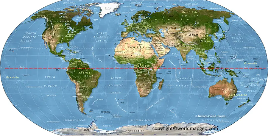
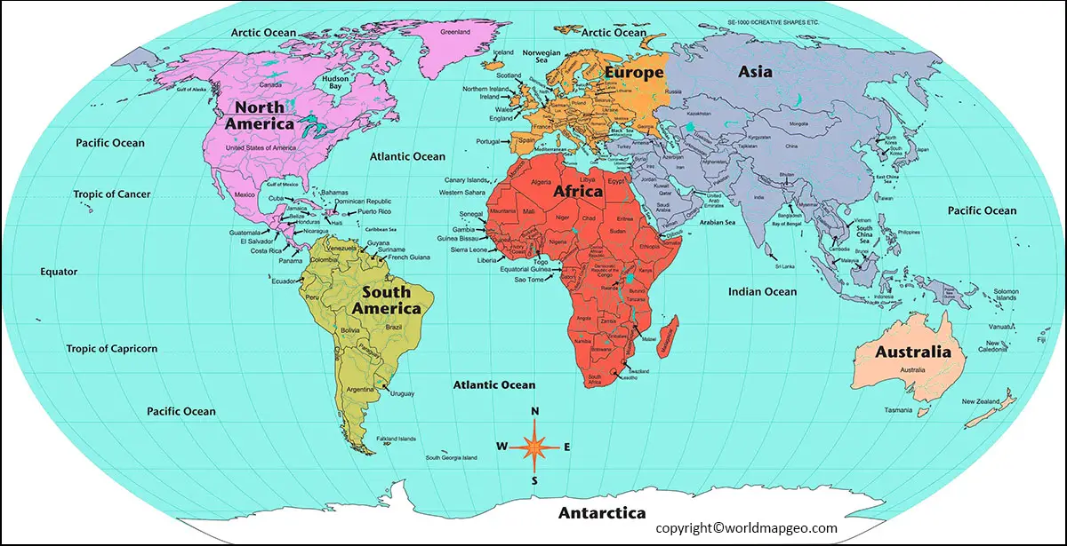
The World Map with Equator is a large circle that circles the Earth and lies on a plane perpendicular to the Earth’s axis. This geographic, or terrestrial, Equator separates the Earth into Northern and Southern hemispheres and serves as the imaginary reference line on the Earth’s surface for calculating latitude.
The celestial Equator is the great circle in astronomy where the plane of the terrestrial Equator intersects the celestial sphere, making it equidistant from the celestial poles. Equinoxes occur twice a year when the Sun is in its plane, and day and night are of equal length everywhere.
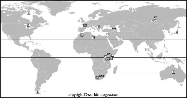
After you’ve downloaded this file, you’ll have access to a blank world map with the Tropic of Cancer, the Equator, and the Tropic of Capricorn marked. Children will readily identify these regions on the map using this resource. Perfect for helping students understand more about the world outside of the classroom. Also, you can find other world maps here for free with their image and PDF format such as:
- Blank World Map
- World Map Physical
- Political World Map
- Printable World Map
- World Map for Kids
- World Map with Continents
World Map with Equator
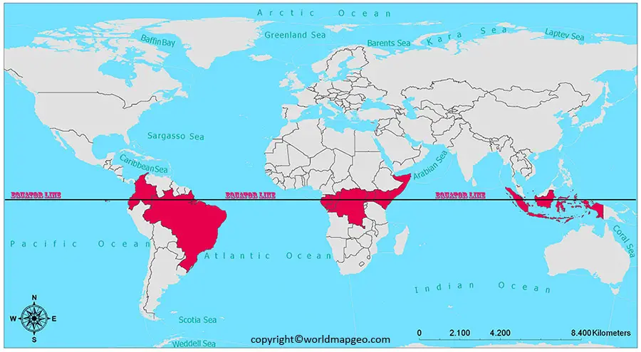
The Equator is a parallel line that circles the Earth’s diameter at its broadest point. Its coordinates are 0°00’00,” and it is halfway between the North and South Poles. The map of the world with equator line spans Ecuador, Indonesia, Kenya, and Brazil and is approximately 24,901 miles long.
Your youngster will better understand world countries, the Equator, the Northern and Southern Hemispheres, and the Cancer and Capricorn Tropics. It’s critical to be aware of the larger world and the numerous countries and cultures that make it up. This tool is ideal for assisting your youngster with visualizing their surroundings.
Map of the world with Equator and Countries
Invite youngsters to label the lines on the Equator Map once downloaded. Then, why not ask your students to mark continents, seas, and oceans on your maps? After that, you may color in your maps, and each student will have a detailed world map to use in class.
If you enjoyed using this Equator Map in your lessons, why not check out some of our other resources to help your students learn more about geography. Check out some of our fantastic suggestions below:
· PowerPoint – World Continents – Alternatively, we have this great PowerPoint with facts, information, and photos to assist youngsters in learning about the world’s continents. Pupils will learn about the various parts of the world, such as Europe, Africa, and America, among others.
· Tropics, Equator, and Hemisphere Ms. PowerPoint -Learn about the many divisions of the world with our helpful PowerPoint. This is an excellent resource for equator lessons.
· World Map of Continents and Oceans – This excellent poster of the Earth’s continents and oceans is a must-have resource for your classroom if you teach your students about the global map. Ideal for incorporating into classroom exhibits.
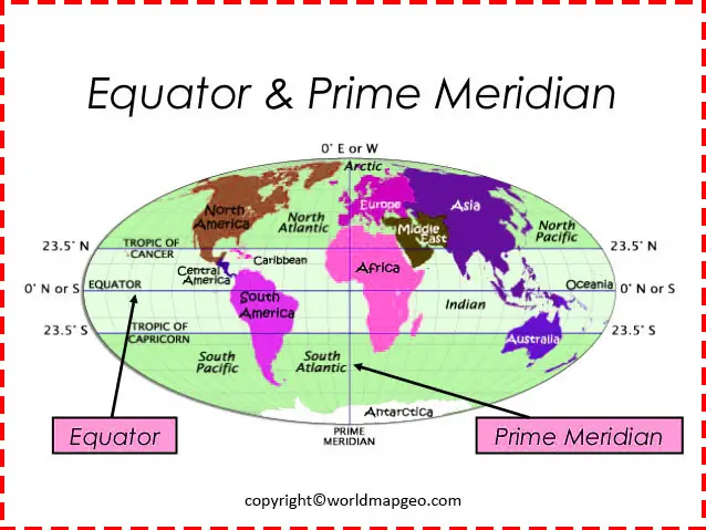
World Map Equator and Prime Meridian
To ensure that you receive unique quality content, all of our resources are created by our expert team and approved by experienced teachers. Perfect for making it simple to plan and prepare your courses ahead of time.
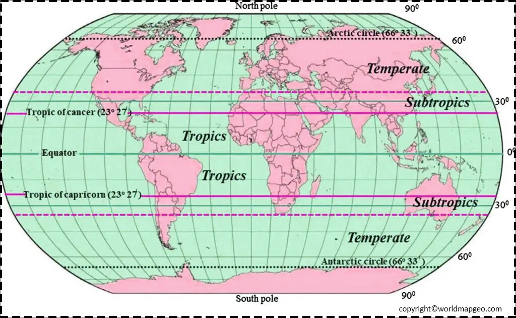
World map with Equators and Tropics
This global map has been left blank to allow your Geography students to do various labeling and coloring activities. For example, you might want them to draw the Equator, the Cancer and Capricorn tropics, a world map with equator and tropics line, and the world’s countries. This is an excellent practice for visual learners who want to improve their location knowledge and world awareness.
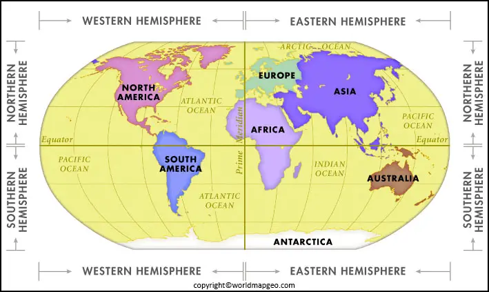
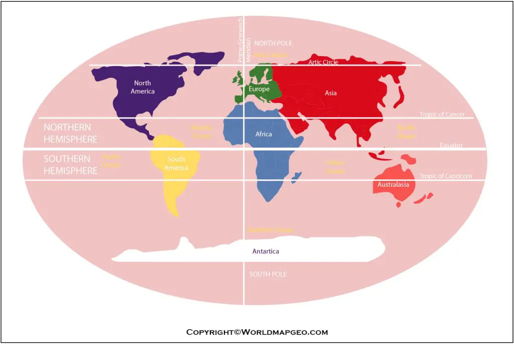
Map World with Hemispheres and Equator
It is necessary to understand the Equator before learning about the world map with the Equator. The Equator is a large circle that circles the globe and is perpendicular to the Earth’s axis. It is equidistant from the geographic poles everywhere. As a result, the global map with the Equator aids in identifying specific geographic areas and things that lie around the Equator and forming the Equator’s axis. All lines and spaces, both geographical and territorial, can be identified on the world map with the Equator.
Labeled World Map with Equator
Labeled World Map Poster – Explore our vibrant and colorful World Map Poster to discover more about different countries worldwide and where they are located. Why not label your own Equator Maps using this resource?
Blank Map World Equators and Tropics
You can also check out here for a blank world map with equator and prime meridian with their image and PDF format. With the help of an image, you would not get confused about the further locations and regions on the map.
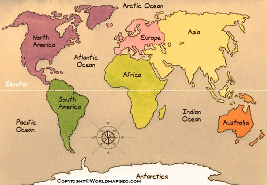
World Map Equatorial Line
The equatorial line, also known as the equator, is an imaginary line that encircles the Earth horizontally, dividing it into the Northern Hemisphere and the Southern Hemisphere. Here’s a detailed description of the equatorial line and its significance:
Location: The equatorial line is situated exactly halfway between the North Pole and the South Pole, at 0 degrees latitude. It passes through several countries and regions, including Ecuador, Brazil, the Democratic Republic of Congo, Kenya, Indonesia, and the Pacific Ocean.
Characteristics: The equator is a circle with a circumference of approximately 40,075 kilometers (24,901 miles), making it the longest parallel of latitude on Earth. It serves as the reference point for measuring latitude, with 0 degrees latitude marking the equator itself.
Climate: The equatorial line plays a significant role in shaping the climate of the regions it crosses. It experiences a tropical climate characterized by high temperatures, high humidity, and abundant rainfall throughout the year. The regions near the equator often have distinct wet and dry seasons and are known for their lush rainforests and diverse ecosystems.
Physical Effects: Due to the Earth’s rotation, regions along the equator experience unique physical phenomena. The equator is the only location on Earth where the centrifugal force resulting from the planet’s rotation exactly balances the force of gravity. As a result, objects at the equator are slightly farther from the center of the Earth and experience a slightly lower gravitational pull compared to other regions.
Day and Night
The equatorial line also influences the length of daylight hours throughout the year. On the two equinoxes, which occur around March 21st and September 21st each year, the sun is directly overhead at noon on the equator, resulting in roughly equal day and night lengths worldwide. This phenomenon gives rise to the term “equinox,” meaning “equal night” in Latin.
Cultural Significance: The equatorial line holds cultural significance for many regions that it traverses. In Ecuador, for example, the country’s name is derived from the Spanish word for “equator.” The capital city of Quito is known for its monument and museum dedicated to the equator, allowing visitors to stand in both the Northern and Southern Hemispheres simultaneously.
Tourism and Exploration: The equator attracts tourists and researchers interested in exploring the unique features and phenomena associated with this line. Visitors often participate in ceremonial crossings, take part in experiments showcasing the Coriolis effect, and learn about the diverse cultures and ecosystems that exist along this important latitude.
The equatorial line serves as a fundamental reference point in geography, climatology, and navigation. It influences climate patterns, physical forces, and the distribution of life on our planet. Understanding the significance of the equator contributes to our knowledge of Earth’s natural systems and the interconnectedness of global phenomena.
Map of World with Equator and Prime Meridian
The world map showcases the equator and prime meridian, two imaginary lines that serve as essential reference points for measuring locations on Earth. Let’s explore their characteristics and significance:
Equator
The equator is an imaginary line that encircles the Earth horizontally, dividing it into the Northern Hemisphere and the Southern Hemisphere. It is located at 0 degrees latitude and stretches approximately 40,075 kilometers (24,901 miles) in length. The equator runs through several countries, including Ecuador, Brazil, Kenya, Indonesia, and the Democratic Republic of Congo.
The equator plays a crucial role in determining climatic zones. Areas near the equator experience a tropical climate with high temperatures, high humidity, and abundant rainfall throughout the year. This region is known for its lush rainforests, diverse ecosystems, and distinct wet and dry seasons.
Additionally, the equator has physical effects due to the Earth’s rotation. It is the only place on Earth where the centrifugal force resulting from the planet’s rotation balances the force of gravity, causing objects at the equator to experience slightly less gravitational pull than in other regions.
Prime Meridian
The prime meridian is an imaginary line that runs vertically from the North Pole to the South Pole, dividing the Earth into the Eastern Hemisphere and the Western Hemisphere. It is located at 0 degrees longitude. The prime meridian passes through Greenwich, London, and is commonly referred to as the Greenwich Meridian.
The prime meridian serves as the reference point for measuring longitude. It is the starting point from which all other longitudes are measured. Longitudes to the east of the prime meridian are expressed as positive values, while those to the west are expressed as negative values.
The prime meridian is of great significance in navigation, cartography, and timekeeping. It helps establish standardized time zones worldwide. The time at the prime meridian is known as Greenwich Mean Time (GMT) or Coordinated Universal Time (UTC). Other time zones are measured based on their offset from GMT.
On the world map, the equator is depicted as a horizontal line, while the prime meridian is represented as a vertical line. They intersect at right angles, dividing the map into four quadrants: Northeast, Northwest, Southeast, and Southwest.
Understanding the equator and prime meridian is crucial for locating and navigating places on Earth. They provide the basis for measuring latitude and longitude, determining climate patterns, and establishing standardized time zones. The equator and prime meridian serve as fundamental reference points, facilitating our understanding of the Earth’s geography and aiding various fields of study.
