Lakes of The World Map: Lakes come in various shapes and sizes, and some are famous for their size, depth, or other qualities. A pond, sea, ocean, river, or lagoon is different from a lake. A lake is a vast body of water with exposed land. Lakes are usually freshwater; however, they can also be saltwater in some situations. Seas and oceans are traditionally deeper than lakes. Plants, fish, and other animals frequent lakes.
Lakes of The World Map
A lakes map of the world showcases the diverse and captivating bodies of water that can be found across the globe. From vast expanses of freshwater to ancient crater lakes, each lake holds its own unique story and ecological significance. The lakes of the world map highlight some of the most prominent and awe-inspiring lakes found on every continent, offering a glimpse into the breathtaking beauty and importance of these water bodies.
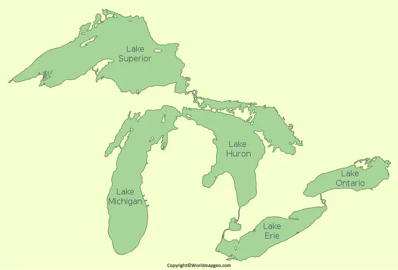
In North America, the Great Lakes stand out as a dominant feature on the lakes of the world map. Comprising Lake Superior, Lake Michigan, Lake Huron, Lake Erie, and Lake Ontario, the Great Lakes are not only impressive in size but also vital for shipping, recreation, and providing freshwater to surrounding regions. Moving to South America, Lake Titicaca, situated on the border of Peru and Bolivia, takes center stage.
It is the largest lake in South America and the highest navigable lake in the world, renowned for its cultural and historical significance to the indigenous communities that inhabit its shores. Check out other Maps about Water Bodies:- Danube River Map, Missouri River Map.
Europe boasts several remarkable lakes, such as Lake Geneva, located on the border of Switzerland and France, renowned for its stunning alpine scenery. In Asia, the enchanting Lake Baikal in Siberia, Russia, stands out as the deepest and oldest freshwater lake on Earth, home to a unique and diverse ecosystem. Heading to Africa, Lake Victoria dominates the lakes of the world map. As the largest lake in Africa and the source of the Nile River, Lake Victoria plays a crucial role in supporting local economies and ecosystems.
Lakes World Map
A lakes world map offers a comprehensive overview of the distribution and diversity of lakes across all continents. These natural wonders can be found in a variety of landscapes, including mountain ranges, rift valleys, coastal regions, and even within volcanic craters. From shimmering turquoise lakes to pristine glacial reservoirs, the lakes world map captures the extraordinary beauty and ecological significance of these bodies of water on a global scale.
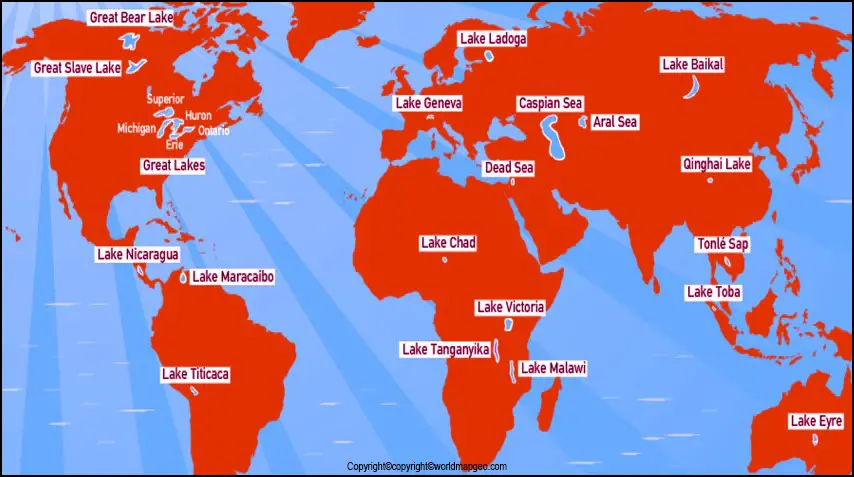
The lakes world map showcases the stunning Lake Louise in the Canadian Rockies, renowned for its turquoise glacial waters and breathtaking mountain backdrop. In South America, the stunning Lake Atitlán in Guatemala draws attention with its tranquil blue waters and picturesque surroundings, nestled between volcanoes and traditional Mayan villages. Journeying to Oceania, the Great Barrier Reef, the world’s largest coral reef system, is home to the mesmerizing Whitsunday Islands, featuring the famous Hill Inlet and Whitehaven Beach, where the ocean meets pristine white sands.
In Africa, the lakes world map highlights Lake Malawi, known for its crystal-clear waters and rich biodiversity. The lake is home to hundreds of species of colorful cichlid fish, making it a popular destination for divers and nature enthusiasts. In Europe, the lakes of Plitvice National Park in Croatia stand out for their cascading waterfalls and interconnected turquoise lakes, creating a breathtaking natural spectacle. Finally, in Asia, the lakes world map includes Lake Pichola in Udaipur, India, known for its romantic setting, featuring majestic palaces and temples reflected in its calm waters.
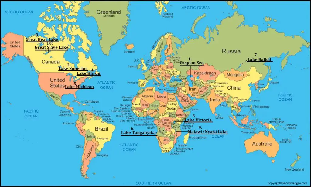
Labeled Lakes of The World Map
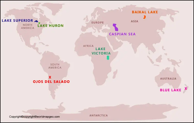
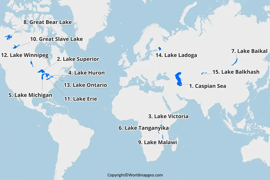
A labeled lakes of the world map provides an informative and detailed representation of significant lakes across the globe. By including labels, this map allows viewers to identify and locate specific lakes easily, enhancing their understanding of the geographic distribution and characteristics of these water bodies. Labeled lakes of the world maps serve as valuable educational resources, enabling exploration and appreciation of the diverse lakes that shape our planet’s landscape.
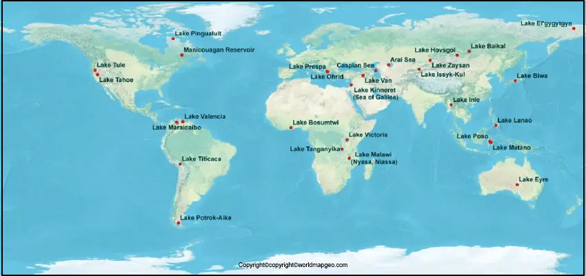
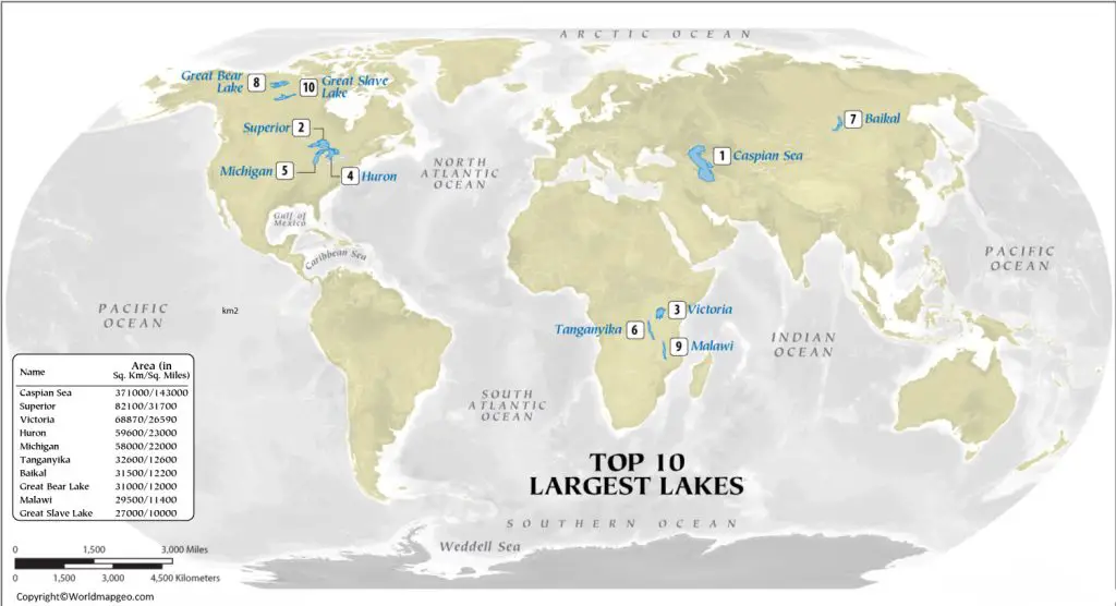
Some key labeled lakes of the world include Lake Baikal in Russia, the world’s deepest and oldest freshwater lake, and the African Great Lakes—Lake Victoria, Lake Tanganyika, and Lake Malawi—known for their enormous size and ecological importance. In North America, the Great Lakes—Superior, Michigan, Huron, Erie, and Ontario—stand out prominently with their strategic locations and extensive freshwater reserves.
Labeled lakes of the world maps also highlight iconic lakes such as Lake Geneva, located between Switzerland and France, renowned for its scenic beauty and cultural significance. The map would include Lake Titicaca, the highest navigable lake in the world, situated between Peru and Bolivia, which plays a vital role in local indigenous cultures. Additionally, Lake Como in Italy, surrounded by charming towns and majestic villas, would find its place on the labeled map, capturing the allure of the Italian Lake District.
With labels providing information about each lake’s name, location, and notable features, this type of map serves as an engaging tool for researchers, students, and travel enthusiasts to explore and appreciate the world’s incredible lakes.
Great Lakes on World Map
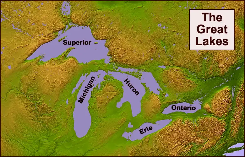
The Great Lakes are a prominent feature on the world map, serving as one of North America’s defining natural wonders. Comprising five interconnected lakes—Superior, Michigan, Huron, Erie, and Ontario—the Great Lakes form the largest group of freshwater lakes on Earth. Their strategic location in the heart of the North American continent, shared between the United States and Canada, makes them a vital hub for transportation, commerce, tourism, and environmental conservation.
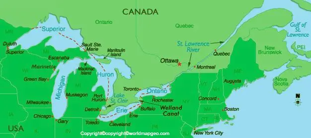
Positioned between the United States and Canada, Lake Superior stands out as the largest and deepest of the Great Lakes. It is known for its stunning natural beauty, with rocky shores, picturesque islands, and pristine wilderness areas. Lake Michigan, the only Great Lake entirely within the United States, boasts a diverse shoreline and is a popular destination for recreational activities such as boating, fishing, and swimming.
Lake Huron, with its scenic coastal areas and historic lighthouses, provides abundant opportunities for outdoor adventures and exploration. Lake Erie, known for its vibrant fishing industry and picturesque islands like Put-in-Bay, offers visitors a chance to experience a mix of natural beauty and cultural attractions. Finally, Lake Ontario, located between the United States and Canada, is renowned for its bustling waterfront cities and Niagara Falls, a world-famous natural wonder.
As a collective entity, the Great Lakes play a crucial role in supporting ecosystems, providing freshwater resources, and serving as an essential transportation route for trade between the Midwest, Canada, and the Atlantic Ocean. The Great Lakes on the world map are a testament to the significance and splendor of these interconnected bodies of water.
Rivers and Lakes of The World Map
A rivers and lakes of the world map offers a comprehensive view of the planet’s hydrological systems, showcasing the intricate network of rivers and the diverse array of lakes found across continents. It highlights the interconnectedness between rivers and lakes, emphasizing their crucial roles in shaping landscapes, supporting ecosystems, and providing essential resources to human communities.
The rivers and lakes of the world map feature iconic water bodies such as the Amazon River in South America, the largest river in the world by discharge volume, and its associated floodplain lakes, which harbor remarkable biodiversity. In Africa, the Nile River, the longest river globally, meanders through various countries, creating a lifeline for human settlements and hosting significant lakes such as Lake Victoria, Lake Tana, and Lake Nasser.
Moving to Asia, the rivers and lakes of the world map would showcase the Yangtze River in China, known for its cultural and economic significance, as well as its connection to the vast Poyang and Dongting Lakes. The Ganges River in India, revered as a sacred river in Hinduism, would also be prominently featured, along with its associated lakes and wetlands.
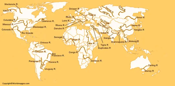
In North America, the Mississippi River, flowing through the United States, stands out as a significant river system, supporting a range of habitats and contributing to the formation of lakes such as Lake Itasca and Lake Pontchartrain. Additionally, the rivers and lakes of the world map would include Europe’s major water bodies, including the Danube River and its associated lakes, as well as the Rhine River and its connection to Lake Constance.
By highlighting the rivers and lakes of the world, this map provides insight into the intricate relationship between water systems and the environment, fostering a greater appreciation for the planet’s freshwater resources and their ecological importance.