A Blank Map of Nepal is a simple map that shows the country’s outline without labels, place names, or extra details. It is widely used by students, teachers, travelers, researchers, and map enthusiasts for learning, classroom activities, geography practice, and presentations. Whether you need a blank outline map for a school project or a printable map for educational purposes, this guide provides everything you need in one place.
Nepal is a landlocked country in South Asia, located between China to the north and India to the south, east, and west. Although Nepal covers a relatively small area, it has a diverse landscape that includes the Himalayas, hills, valleys, rivers, forests, and fertile plains. A blank map makes it easy to identify these regions and practice marking important locations.
On this page, you’ll find different types of Blank Maps of Nepal, including printable PDF maps, outline maps, political maps, province maps, district maps, and black-and-white versions. You’ll also learn how to use these maps for education, travel planning, competitive exams, and geography practice.
Download Blank Map of Nepal
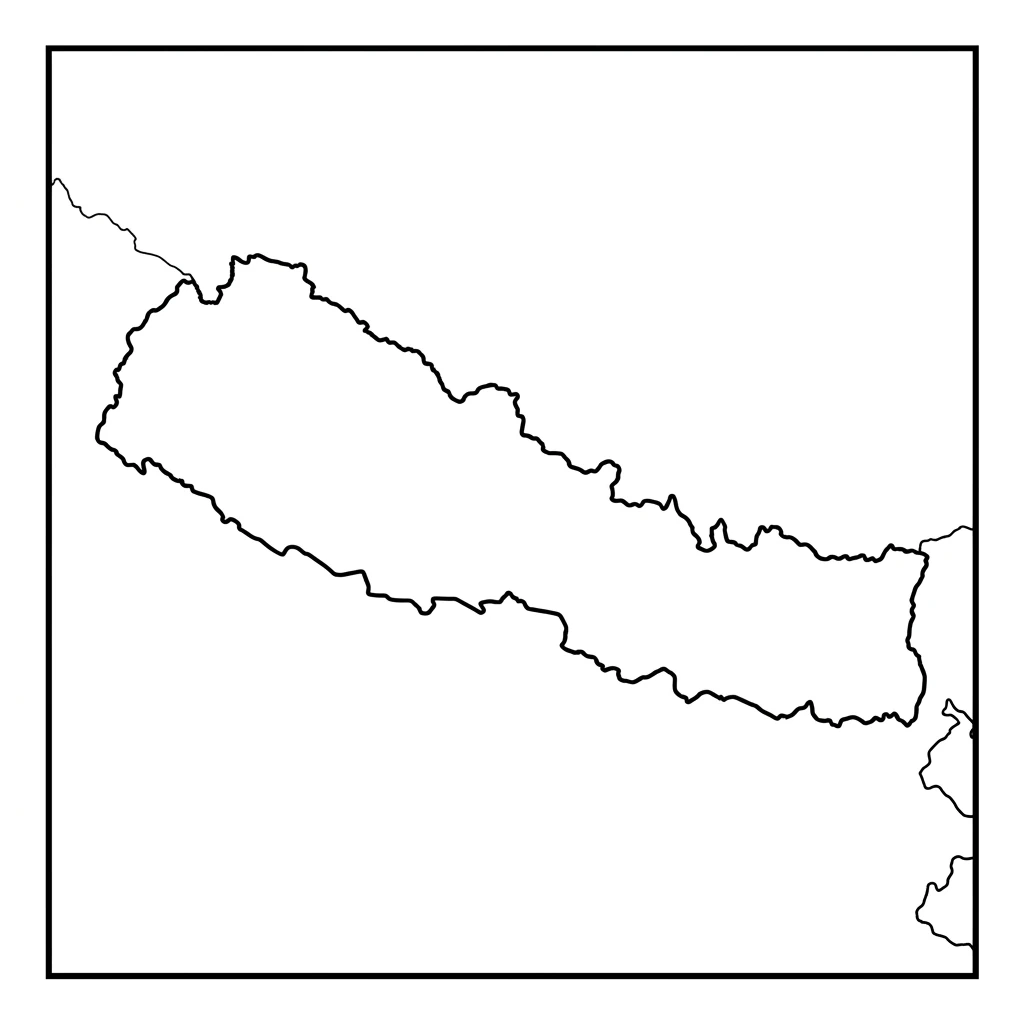
If you’re looking for a Printable Blank Map of Nepal, several versions are available for different purposes. Choose the one that best fits your needs.
You can download:
- Printable Blank Map of Nepal (PDF)
- High-Resolution PNG Map
- Blank Outline Map of Nepal
- Nepal Map with Provincial Boundaries
- Nepal District Blank Map
- Black and White Nepal Map
- Nepal Map for School Projects
- Nepal Worksheet Map
- A4 Printable Nepal Map
These maps are useful for classroom learning, map-labeling exercises, competitive exam preparation, travel planning, and research projects.
Quick Overview of Nepal
Before using a blank map, it’s helpful to understand some basic facts about the country.
| Feature | Information |
|---|---|
| Country | Nepal |
| Continent | Asia |
| Region | South Asia |
| Capital City | Kathmandu |
| Largest City | Kathmandu |
| Area | About 147,516 sq km |
| Population | Over 30 million |
| Official Language | Nepali |
| Currency | Nepalese Rupee (NPR) |
| Time Zone | Nepal Time (NPT), UTC+5:45 |
| Neighboring Countries | India and China |
These details help students and travelers better understand Nepal while working with a blank map.
What Is a Blank Map of Nepal?
A Blank Map of Nepal is an unlabeled map that displays the shape of the country without names of cities, provinces, districts, rivers, or mountains. It provides a clean outline that users can customize according to their needs.
Unlike a labeled map, a blank map allows users to add their own information. For example, students can mark provinces, rivers, mountain ranges, or neighboring countries as part of geography assignments. Teachers often use blank maps for quizzes and classroom activities because they encourage active learning.
A blank map is also useful for researchers, travelers, and businesses that need a simple base map for presentations or planning.
Why Use a Blank Map of Nepal?
A blank map is more than just an outline. It is a practical learning tool that can be used in many different ways.
For Students
Students use blank maps to:
- Practice identifying provinces
- Mark districts
- Label major cities
- Locate rivers and lakes
- Learn mountain ranges
- Prepare for geography exams
Blank maps help improve map-reading skills and make learning more interactive.
For Teachers
Teachers often use printable blank maps to create:
- Geography worksheets
- Classroom quizzes
- Homework assignments
- Map-labeling activities
- Educational presentations
Since the maps do not contain labels, students can complete them independently.
For Travelers
Travelers can use a blank map to:
- Plan routes
- Mark tourist attractions
- Identify national parks
- Track trekking routes
- Organize road trips
A simple map makes trip planning easier and more organized.
For Researchers
Researchers and professionals use blank maps to:
- Present geographic data
- Show survey results
- Create custom maps
- Highlight study areas
- Display regional information
Because there are no labels, the map can be customized for different projects.
Types of Blank Maps of Nepal
Different users need different kinds of maps. Below are the most common types of blank Nepal maps.
Blank Outline Map of Nepal
The Blank Outline Map of Nepal shows only the country’s outer boundary without any internal divisions or labels.
This version is ideal for:
- School assignments
- Geography practice
- Map drawing
- Educational worksheets
- Quiz competitions
It is the simplest version of the map and is often the first choice for students.
Printable Blank Map of Nepal
A Printable Blank Map of Nepal is designed for easy printing on standard paper sizes such as A4 or Letter size.
It is commonly available in:
- PNG
- JPG
Printable maps are useful because they can be used without an internet connection and are easy to distribute in classrooms.
Blank Political Map of Nepal
A Blank Political Map displays the country’s political boundaries while leaving out names and labels.
Depending on the version, it may include:
- Provincial boundaries
- District boundaries
- National border
- Capital location (optional)
This map is useful for learning Nepal’s administrative divisions.
Blank Physical Map of Nepal
A Blank Physical Map focuses on natural features instead of administrative boundaries.
It can be used to identify:
- Himalayan mountain ranges
- Hills
- Valleys
- Rivers
- Lakes
- National parks
Students often use this map to study Nepal’s diverse geography.
Black and White Blank Map
A Black and White Blank Map of Nepal is perfect for printing and coloring.
It is frequently used for:
- Classroom activities
- Coloring exercises
- Geography practice
- School projects
Since there are no colors, students can mark different regions using colored pencils or markers.
Nepal at a Glance
Nepal is one of the world’s most unique countries because of its incredible natural diversity. Despite its relatively small size, it contains some of the highest mountains on Earth as well as fertile plains in the south.
The country stretches for approximately 885 kilometers from east to west, while its width varies between 145 and 241 kilometers from north to south.
Nepal shares international borders with:
- China (Tibet Autonomous Region) to the north
- India to the east, west, and south
Its central location in the Himalayas makes it one of the world’s most popular destinations for trekking, mountaineering, and nature tourism.
Administrative Divisions of Nepal
Understanding Nepal’s administrative structure makes it easier to use a blank map correctly.
Today, Nepal is divided into:
- 7 Provinces
- 77 Districts
- Hundreds of Local Municipalities and Rural Municipalities
Students frequently use blank maps to practice locating these provinces and districts during geography lessons and competitive exams.
The seven provinces are:
- Koshi Province
- Madhesh Province
- Bagmati Province
- Gandaki Province
- Lumbini Province
- Karnali Province
- Sudurpashchim Province
Learning these provinces is one of the most common uses of a printable blank map of Nepal.
Why Blank Maps Are Important for Learning Geography
Blank maps encourage active learning instead of passive reading. Rather than simply looking at labeled locations, users identify and mark places on their own. This improves memory, spatial understanding, and map-reading skills.
Schools, colleges, and coaching institutes often use blank maps because they help students:
- Remember province names
- Identify district boundaries
- Understand neighboring countries
- Learn Nepal’s physical features
- Practice for competitive examinations
- Build confidence in geography
Whether you’re a student, teacher, traveler, or researcher, a Blank Map of Nepal is a valuable resource for learning and planning.
Blank Map of Nepal with Provinces
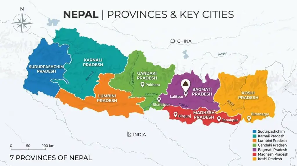
A Blank Map of Nepal with Provinces shows the boundaries of Nepal’s seven provinces without labels or place names. This type of map is commonly used in schools, colleges, and competitive exams because it allows users to identify and label each province on their own.
Since Nepal adopted a federal system, understanding the provincial divisions has become an important part of geography education. A blank province map helps students remember the location, shape, and boundaries of each province more effectively.
The seven provinces shown on the map are:
| Province | Provincial Capital |
|---|---|
| Koshi Province | Biratnagar |
| Madhesh Province | Janakpur |
| Bagmati Province | Hetauda |
| Gandaki Province | Pokhara |
| Lumbini Province | Deukhuri (Dang) |
| Karnali Province | Birendranagar |
| Sudurpashchim Province | Godawari |
A printable province map is ideal for:
- Geography practice
- School projects
- Classroom quizzes
- Civil service exam preparation
- General knowledge learning
Blank Map of Nepal with Districts
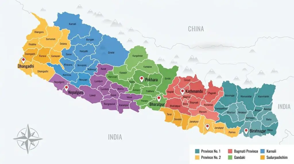
Nepal is divided into 77 districts, and a Blank District Map of Nepal helps users learn these administrative divisions without pre-filled labels.
District maps are especially useful for:
- UPSC and PSC aspirants
- Geography students
- Teachers
- Researchers
- Government exam preparation
Students can use the blank map to mark district names, district headquarters, or important landmarks.
Some well-known districts include:
- Kathmandu
- Lalitpur
- Bhaktapur
- Chitwan
- Kaski
- Mustang
- Dolpa
- Solukhumbu
- Jhapa
- Kailali
Using a blank district map regularly helps improve map-reading skills and geographical knowledge.
Blank Outline Map of Nepal
A Blank Outline Map of Nepal displays only the outer shape of the country without any internal boundaries, labels, rivers, or roads.
This is one of the most downloaded map formats because it is simple and easy to customize.
You can use an outline map to:
- Draw provincial boundaries
- Mark districts
- Label cities
- Identify neighboring countries
- Highlight mountain ranges
- Practice map drawing
- Create educational worksheets
Teachers often choose outline maps because they encourage students to complete the map independently.
Blank Political Map of Nepal
A Blank Political Map focuses on Nepal’s administrative divisions while leaving out labels. Depending on the version, it may show:
- National boundary
- Provincial boundaries
- District boundaries
- Capital location
- Major administrative regions
Political maps are useful for understanding how Nepal is organized from an administrative perspective.
They are widely used in:
- Schools
- Government offices
- Geography classrooms
- Research projects
- Educational presentations
Blank Physical Map of Nepal
Unlike a political map, a Blank Physical Map of Nepal highlights the country’s natural landscape.
It allows users to study important physical features such as:
- Himalayan mountain ranges
- Hills
- Valleys
- Rivers
- Lakes
- Forests
- Plains
Because the labels are removed, students can identify these features themselves, making it an excellent learning resource.
Nepal Location Map
A Nepal Location Map helps users understand where Nepal is situated in South Asia.
Nepal is located between two of the world’s largest countries:
- China (Tibet Autonomous Region) to the north
- India to the south, east, and west
Although Nepal does not have direct access to the sea, its strategic location in the Himalayas makes it one of Asia’s most important mountain nations.
The location map is commonly used in:
- Geography textbooks
- Travel guides
- Educational presentations
- Research papers
Nepal Border Map
A Nepal Border Map highlights the country’s international boundaries.
Nepal shares approximately:
| Bordering Country | Direction |
|---|---|
| China | North |
| India | East, South, and West |
Unlike many countries, Nepal is completely landlocked and has no coastline.
The border map helps users understand:
- International boundaries
- Border crossings
- Neighboring countries
- Trade routes
- Geographic position
It is especially useful for students learning about South Asian geography.
Nepal Administrative Map
An Administrative Map of Nepal shows how the country is divided for governance and local administration.
It includes:
- Provincial boundaries
- District boundaries
- Municipalities
- Rural municipalities
- Provincial capitals
This map is useful for:
- Government planning
- Census studies
- Development projects
- Educational research
Many students use an administrative map alongside a blank map to practice identifying provinces and districts.
Major Cities to Mark on a Blank Map of Nepal
One of the best ways to learn geography is by labeling important cities on a blank map.
Here are some of Nepal’s major cities:
| City | Province |
|---|---|
| Kathmandu | Bagmati |
| Pokhara | Gandaki |
| Biratnagar | Koshi |
| Janakpur | Madhesh |
| Bharatpur | Bagmati |
| Nepalgunj | Lumbini |
| Dhangadhi | Sudurpashchim |
| Birendranagar | Karnali |
| Hetauda | Bagmati |
| Butwal | Lumbini |
Students often use blank maps to locate these cities during classroom activities and examinations.
Major Rivers to Label on a Blank Nepal Map
Nepal has many rivers that originate in the Himalayas and flow into India.
Some of the most important rivers include:
- Koshi River
- Gandaki River
- Karnali River
- Bagmati River
- Mahakali River
- Rapti River
- Bheri River
- Seti River
- Arun River
- Trishuli River
Marking these rivers on a blank map helps students understand Nepal’s drainage system and river basins.
Major Mountain Ranges to Identify
Nepal is home to eight of the world’s fourteen highest peaks.
Important mountain ranges and peaks include:
- Mount Everest
- Kanchenjunga
- Lhotse
- Makalu
- Cho Oyu
- Dhaulagiri
- Manaslu
- Annapurna
Using a blank physical map, students can practice locating these famous peaks and understand Nepal’s mountainous terrain.
Which Blank Nepal Map Should You Choose?
Different types of maps serve different purposes. Choosing the right map depends on your needs.
| Map Type | Best For |
|---|---|
| Blank Outline Map | Basic geography practice |
| Printable Blank Map | School assignments |
| Political Blank Map | Administrative divisions |
| Physical Blank Map | Landforms and rivers |
| Province Map | Learning the seven provinces |
| District Map | Competitive exam preparation |
| Border Map | Neighboring countries |
| Location Map | Understanding Nepal’s position in Asia |
If you’re preparing for an exam, a Blank Province Map or Blank District Map is the best choice. For classroom activities and map-labeling exercises, a Blank Outline Map is usually the most practical option.
How to Use a Blank Map of Nepal
A Blank Map of Nepal is a flexible resource that can be used for education, travel planning, research, and presentations. Since the map does not contain labels, users can customize it based on their specific needs.
Here are some of the most common ways to use a blank Nepal map:
- Label the seven provinces.
- Mark all 77 districts.
- Identify the capital city, Kathmandu.
- Locate major rivers and lakes.
- Mark the mountain ranges and peaks.
- Show neighboring countries.
- Practice for geography exams.
- Create custom travel routes.
- Prepare classroom worksheets.
- Design presentations and reports.
Whether you’re a student, teacher, traveler, or researcher, a blank map allows you to add only the information you need.
Educational Uses of a Blank Map of Nepal
Blank maps are widely used in schools, colleges, and coaching institutes because they encourage active learning.
Students can use a blank Nepal map to:
- Learn the country’s shape and boundaries.
- Identify all seven provinces.
- Practice locating districts.
- Mark important cities.
- Label rivers and mountain ranges.
- Understand Nepal’s physical geography.
- Prepare for geography quizzes and competitive exams.
Teachers often distribute printable blank maps during classroom activities because they help students improve memory and map-reading skills.
Travel Planning with a Blank Map of Nepal
Travelers can use a blank map to organize their trips and better understand Nepal’s geography.
A printable Nepal map helps you:
- Plan trekking routes.
- Mark popular tourist destinations.
- Identify national parks.
- Track road trip routes.
- Understand provincial boundaries.
- Locate airports and major highways.
Popular places that travelers often mark include:
- Kathmandu
- Pokhara
- Chitwan National Park
- Lumbini
- Everest Base Camp
- Annapurna Conservation Area
- Langtang National Park
- Janakpur
- Mustang
Using a blank map before traveling makes it easier to visualize distances and plan a more efficient itinerary.
Research and Business Uses
Blank maps are not only for students. Researchers, businesses, and government organizations also use them for planning and presentations.
Common applications include:
- Population studies
- Environmental research
- Tourism planning
- Infrastructure projects
- Disaster management
- Market analysis
- Census mapping
- Development planning
- Government reports
Since a blank map contains no labels, it can easily be customized with charts, symbols, colors, and annotations.
Benefits of Using a Printable Blank Map of Nepal
A printable map offers several advantages over a digital map.
Some key benefits include:
- Easy to print on A4 or Letter-size paper.
- No internet connection required.
- Ideal for classrooms and workshops.
- Suitable for map-labeling exercises.
- Helps improve geographical knowledge.
- Easy to color and annotate.
- Useful for competitive exam preparation.
- Can be laminated for repeated use.
Because of these benefits, printable maps remain one of the most popular educational resources.
Interesting Facts About the Blank Map of Nepal
Nepal is known for its unique geography, rich culture, and breathtaking mountain landscapes. Here are some interesting facts about the country.
1. Home to Mount Everest
Nepal is home to Mount Everest, the highest mountain in the world at 8,848.86 meters (29,031.7 feet) above sea level.
2. A Landlocked Country
Nepal does not have a coastline. It is surrounded by India and China.
3. Seven Federal Provinces
Nepal is divided into seven provinces, making it easier to manage administration and local governance.
4. Seventy-Seven Districts
The country has 77 districts, each with its own administrative headquarters.
5. Unique Time Zone
Nepal follows Nepal Standard Time (NPT), which is UTC+5:45. This 45-minute offset is uncommon compared to most countries.
6. Eight of the World’s Highest Mountains
Nepal is home to eight of the world’s fourteen peaks above 8,000 meters, making it one of the world’s top destinations for mountaineering.
7. Birthplace of Lord Buddha
Lumbini, located in southern Nepal, is widely recognized as the birthplace of Lord Buddha and is a UNESCO World Heritage Site.
8. Rich Biodiversity
Despite its small size, Nepal has tropical forests, alpine meadows, glaciers, and diverse wildlife, including Bengal tigers, one-horned rhinoceroses, and snow leopards.
Frequently Asked Questions (FAQs)
Q. What is a Blank Map of Nepal?
A Blank Map of Nepal is an unlabeled map that shows the country’s outline without names of provinces, districts, cities, rivers, or mountains. It is commonly used for education, map practice, and research.
Q. Where can I download a Printable Blank Map of Nepal?
You can download a printable blank Nepal map in formats such as PDF, PNG, or JPG from educational and map websites. These maps are suitable for school projects, classroom activities, and personal use.
Q. How many provinces are shown on a Blank Nepal Map?
Nepal has seven provinces, and most province maps display their boundaries without labels so users can practice identifying them.
Q. How many districts are there in Nepal?
Nepal has 77 districts, organized within the country’s seven provinces.
Q. What is the capital of Nepal?
Kathmandu is the capital and largest city of Nepal. It is located in Bagmati Province.
Q. Which countries border Nepal?
Nepal shares its borders with China to the north and India to the east, south, and west.
Q. What is the difference between a blank map and an outline map?
A blank map may include boundaries without labels, while an outline map usually shows only the country’s outer shape. Both are useful for educational activities and map practice.
Q. Why do students use a Blank Map of Nepal?
Students use blank maps to learn geography, identify provinces and districts, mark rivers and mountains, and prepare for school exams and competitive tests.
Q. Can I use a Blank Nepal Map for school projects?
Yes. Blank maps are ideal for school assignments, geography presentations, science projects, and classroom worksheets because they allow students to add their own labels and notes.
Q. What is a Blank Political Map of Nepal?
A blank political map shows provincial or district boundaries without labels. It helps users understand Nepal’s administrative divisions.
Q. What is a Blank Physical Map of Nepal?
A blank physical map highlights natural features such as mountains, rivers, valleys, and plains without place names, making it useful for geography practice.
Q. What is the best map for learning Nepal’s provinces?
A Blank Map of Nepal with Provinces is the best option for learning provincial boundaries and capitals because it focuses on the country’s seven federal provinces.
Q. Is Nepal a landlocked country?
Yes. Nepal is a landlocked country with no coastline. It is located between China and India.
Q. Can I print a Blank Map of Nepal?
Yes. Most blank maps are available in printable formats such as PDF and PNG and can be printed on standard paper sizes.
Q. What is Nepal famous for?
Nepal is famous for Mount Everest, the Himalayas, trekking routes, Lumbini (the birthplace of Lord Buddha), rich cultural heritage, and diverse landscapes.
Conclusion
A Blank Map of Nepal is a valuable resource for anyone who wants to learn, teach, or explore the geography of Nepal. Whether you need an outline map for classroom activities, a province map for exam preparation, or a printable map for travel planning, having the right version makes learning easier and more engaging.
This guide includes information about printable blank maps, outline maps, political maps, physical maps, province maps, and district maps. It also explains how to use these maps for education, research, and tourism while providing useful facts and answers to common questions.
Choose the map format that best suits your needs, download a printable version, and start exploring Nepal’s provinces, districts, rivers, mountains, and neighboring countries with confidence.